You are here: Home > Network List > TA - USArray Transportable Network (new EarthScope stations) Stations List
> Station V23A Ortiz Mt. (NFS), Santa Fe National Forest, NM, USA > Earthquake Result Viewer
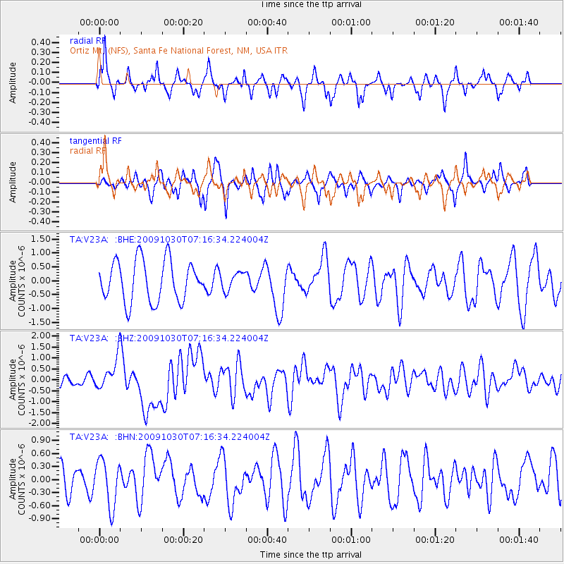
V23A Ortiz Mt. (NFS), Santa Fe National Forest, NM, USA - Earthquake Result Viewer
*The percent match for this event was below the threshold and hence no stack was calculated.
| Earthquake location: |
Ryukyu Islands, Japan |
| Earthquake latitude/longitude: |
29.2/129.8 |
| Earthquake time(UTC): |
2009/10/30 (303) 07:03:39 GMT |
| Earthquake Depth: |
34 km |
| Earthquake Magnitude: |
6.3 MB, 6.8 MS, 6.8 MW, 6.8 MW |
| Earthquake Catalog/Contributor: |
WHDF/NEIC |
|
| Network: |
TA USArray Transportable Network (new EarthScope stations) |
| Station: |
V23A Ortiz Mt. (NFS), Santa Fe National Forest, NM, USA |
| Lat/Lon: |
35.75 N/106.18 W |
| Elevation: |
1991 m |
|
| Distance: |
96.6 deg |
| Az: |
42.74 deg |
| Baz: |
313.172 deg |
| Ray Param: |
$rayparam |
*The percent match for this event was below the threshold and hence was not used in the summary stack. |
|
| Radial Match: |
54.06201 % |
| Radial Bump: |
290 |
| Transverse Match: |
56.23309 % |
| Transverse Bump: |
359 |
| SOD ConfigId: |
2622 |
| Insert Time: |
2010-03-06 23:21:27.213 +0000 |
| GWidth: |
2.5 |
| Max Bumps: |
400 |
| Tol: |
0.001 |
|
Signal To Noise
| Channel | StoN | STA | LTA |
| TA:V23A: :BHZ:20091030T07:16:34.224004Z | 3.462702 | 7.4429454E-7 | 2.1494616E-7 |
| TA:V23A: :BHN:20091030T07:16:34.224004Z | 1.2853746 | 5.479567E-7 | 4.2630117E-7 |
| TA:V23A: :BHE:20091030T07:16:34.224004Z | 0.43817827 | 3.2342024E-7 | 7.3810196E-7 |
| Arrivals |
| Ps | |
| PpPs | |
| PsPs/PpSs | |


