You are here: Home > Network List > TA - USArray Transportable Network (new EarthScope stations) Stations List
> Station J17K VABM Dome, AK, USA > Earthquake Result Viewer
J17K VABM Dome, AK, USA - Earthquake Result Viewer
| Earthquake location: |
Southeast Of Honshu, Japan |
| Earthquake latitude/longitude: |
29.1/139.3 |
| Earthquake time(UTC): |
2019/06/04 (155) 04:39:17 GMT |
| Earthquake Depth: |
430 km |
| Earthquake Magnitude: |
6.3 Mww |
| Earthquake Catalog/Contributor: |
NEIC PDE/us |
|
| Network: |
TA USArray Transportable Network (new EarthScope stations) |
| Station: |
J17K VABM Dome, AK, USA |
| Lat/Lon: |
63.40 N/159.08 W |
| Elevation: |
323 m |
|
| Distance: |
51.8 deg |
| Az: |
30.285 deg |
| Baz: |
258.703 deg |
| Ray Param: |
0.065420546 |
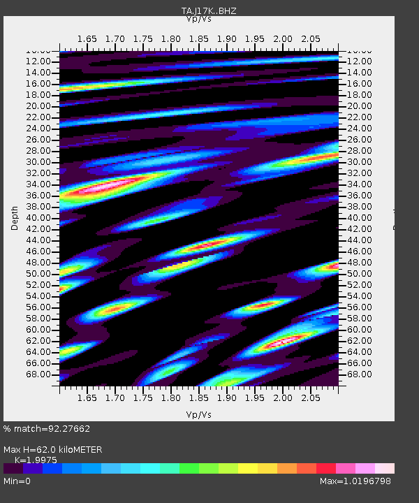
| Estimated Moho Depth: |
62.0 km |
| Estimated Crust Vp/Vs: |
2.00 |
| Assumed Crust Vp: |
6.276 km/s |
| Estimated Crust Vs: |
3.142 km/s |
| Estimated Crust Poisson's Ratio: |
0.33 |
|
| Radial Match: |
92.27662 % |
| Radial Bump: |
400 |
| Transverse Match: |
86.764786 % |
| Transverse Bump: |
400 |
| SOD ConfigId: |
18369291 |
| Insert Time: |
2019-06-18 04:48:20.878 +0000 |
| GWidth: |
2.5 |
| Max Bumps: |
400 |
| Tol: |
0.001 |
|

Signal To Noise
| Channel | StoN | STA | LTA |
| TA:J17K: :BHZ:20190604T04:47:12.874993Z | 126.38845 | 6.881111E-6 | 5.4444143E-8 |
| TA:J17K: :BHN:20190604T04:47:12.874993Z | 39.567604 | 1.6815256E-6 | 4.2497533E-8 |
| TA:J17K: :BHE:20190604T04:47:12.874993Z | 71.61442 | 3.3364324E-6 | 4.6588838E-8 |
| Arrivals |
| Ps | 10 SECOND |
| PpPs | 28 SECOND |
| PsPs/PpSs | 39 SECOND |


