You are here: Home > Network List > TA - USArray Transportable Network (new EarthScope stations) Stations List
> Station J20K Nowitna River, AK, USA > Earthquake Result Viewer
J20K Nowitna River, AK, USA - Earthquake Result Viewer
| Earthquake location: |
Southeast Of Honshu, Japan |
| Earthquake latitude/longitude: |
29.1/139.3 |
| Earthquake time(UTC): |
2019/06/04 (155) 04:39:17 GMT |
| Earthquake Depth: |
430 km |
| Earthquake Magnitude: |
6.3 Mww |
| Earthquake Catalog/Contributor: |
NEIC PDE/us |
|
| Network: |
TA USArray Transportable Network (new EarthScope stations) |
| Station: |
J20K Nowitna River, AK, USA |
| Lat/Lon: |
64.18 N/154.15 W |
| Elevation: |
314 m |
|
| Distance: |
54.1 deg |
| Az: |
29.757 deg |
| Baz: |
262.804 deg |
| Ray Param: |
0.06398336 |
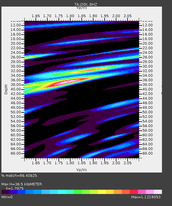
| Estimated Moho Depth: |
36.5 km |
| Estimated Crust Vp/Vs: |
1.79 |
| Assumed Crust Vp: |
6.566 km/s |
| Estimated Crust Vs: |
3.673 km/s |
| Estimated Crust Poisson's Ratio: |
0.27 |
|
| Radial Match: |
96.40625 % |
| Radial Bump: |
400 |
| Transverse Match: |
90.06169 % |
| Transverse Bump: |
400 |
| SOD ConfigId: |
18369291 |
| Insert Time: |
2019-06-18 04:48:23.233 +0000 |
| GWidth: |
2.5 |
| Max Bumps: |
400 |
| Tol: |
0.001 |
|
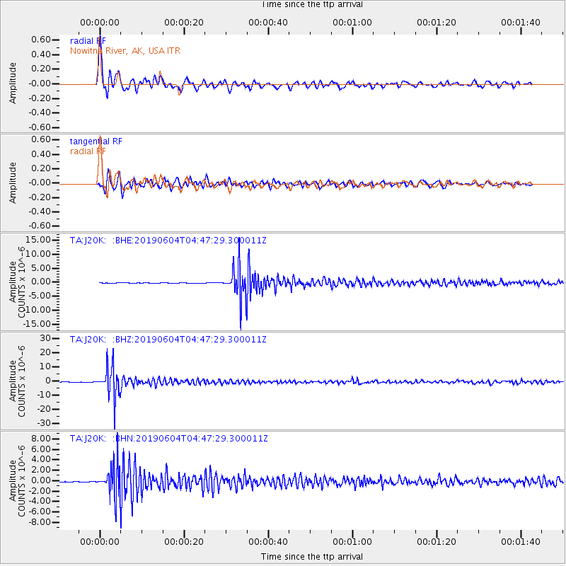
Signal To Noise
| Channel | StoN | STA | LTA |
| TA:J20K: :BHZ:20190604T04:47:29.300011Z | 314.09537 | 1.0584948E-5 | 3.3699788E-8 |
| TA:J20K: :BHN:20190604T04:47:29.300011Z | 78.637115 | 2.9505527E-6 | 3.7521122E-8 |
| TA:J20K: :BHE:20190604T04:47:29.300011Z | 179.80922 | 5.512035E-6 | 3.065491E-8 |
| Arrivals |
| Ps | 4.6 SECOND |
| PpPs | 15 SECOND |
| PsPs/PpSs | 19 SECOND |


