You are here: Home > Network List > TA - USArray Transportable Network (new EarthScope stations) Stations List
> Station L19K White Mountain, AK, USA > Earthquake Result Viewer
L19K White Mountain, AK, USA - Earthquake Result Viewer
| Earthquake location: |
Southeast Of Honshu, Japan |
| Earthquake latitude/longitude: |
29.1/139.3 |
| Earthquake time(UTC): |
2019/06/04 (155) 04:39:17 GMT |
| Earthquake Depth: |
430 km |
| Earthquake Magnitude: |
6.3 Mww |
| Earthquake Catalog/Contributor: |
NEIC PDE/us |
|
| Network: |
TA USArray Transportable Network (new EarthScope stations) |
| Station: |
L19K White Mountain, AK, USA |
| Lat/Lon: |
62.18 N/154.85 W |
| Elevation: |
650 m |
|
| Distance: |
53.5 deg |
| Az: |
32.176 deg |
| Baz: |
263.602 deg |
| Ray Param: |
0.06433225 |
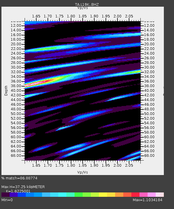
| Estimated Moho Depth: |
37.25 km |
| Estimated Crust Vp/Vs: |
1.62 |
| Assumed Crust Vp: |
6.438 km/s |
| Estimated Crust Vs: |
3.968 km/s |
| Estimated Crust Poisson's Ratio: |
0.19 |
|
| Radial Match: |
86.88774 % |
| Radial Bump: |
400 |
| Transverse Match: |
77.53653 % |
| Transverse Bump: |
400 |
| SOD ConfigId: |
18369291 |
| Insert Time: |
2019-06-18 04:48:32.190 +0000 |
| GWidth: |
2.5 |
| Max Bumps: |
400 |
| Tol: |
0.001 |
|

Signal To Noise
| Channel | StoN | STA | LTA |
| TA:L19K: :BHZ:20190604T04:47:25.325005Z | 144.07254 | 5.3990057E-6 | 3.747422E-8 |
| TA:L19K: :BHN:20190604T04:47:25.325005Z | 22.808035 | 9.688179E-7 | 4.2477044E-8 |
| TA:L19K: :BHE:20190604T04:47:25.325005Z | 58.07506 | 2.5590637E-6 | 4.406476E-8 |
| Arrivals |
| Ps | 3.8 SECOND |
| PpPs | 14 SECOND |
| PsPs/PpSs | 18 SECOND |


