You are here: Home > Network List > TA - USArray Transportable Network (new EarthScope stations) Stations List
> Station M17K Holitna River, AK, USA > Earthquake Result Viewer
M17K Holitna River, AK, USA - Earthquake Result Viewer
| Earthquake location: |
Southeast Of Honshu, Japan |
| Earthquake latitude/longitude: |
29.1/139.3 |
| Earthquake time(UTC): |
2019/06/04 (155) 04:39:17 GMT |
| Earthquake Depth: |
430 km |
| Earthquake Magnitude: |
6.3 Mww |
| Earthquake Catalog/Contributor: |
NEIC PDE/us |
|
| Network: |
TA USArray Transportable Network (new EarthScope stations) |
| Station: |
M17K Holitna River, AK, USA |
| Lat/Lon: |
61.40 N/157.44 W |
| Elevation: |
387 m |
|
| Distance: |
52.2 deg |
| Az: |
32.955 deg |
| Baz: |
261.8 deg |
| Ray Param: |
0.065164365 |
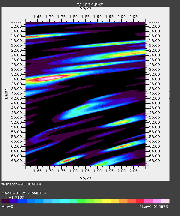
| Estimated Moho Depth: |
33.25 km |
| Estimated Crust Vp/Vs: |
1.71 |
| Assumed Crust Vp: |
6.155 km/s |
| Estimated Crust Vs: |
3.594 km/s |
| Estimated Crust Poisson's Ratio: |
0.24 |
|
| Radial Match: |
93.864044 % |
| Radial Bump: |
400 |
| Transverse Match: |
91.31761 % |
| Transverse Bump: |
361 |
| SOD ConfigId: |
18369291 |
| Insert Time: |
2019-06-18 04:48:37.084 +0000 |
| GWidth: |
2.5 |
| Max Bumps: |
400 |
| Tol: |
0.001 |
|

Signal To Noise
| Channel | StoN | STA | LTA |
| TA:M17K: :BHZ:20190604T04:47:15.874993Z | 166.85698 | 1.3098514E-5 | 7.8501444E-8 |
| TA:M17K: :BHN:20190604T04:47:15.874993Z | 52.93656 | 3.4462544E-6 | 6.510159E-8 |
| TA:M17K: :BHE:20190604T04:47:15.874993Z | 67.296646 | 5.1645557E-6 | 7.674314E-8 |
| Arrivals |
| Ps | 4.0 SECOND |
| PpPs | 14 SECOND |
| PsPs/PpSs | 18 SECOND |


