You are here: Home > Network List > TS - TERRAscope (Southern California Seismic Network) Stations List
> Station GSC Goldston, California, USA > Earthquake Result Viewer
GSC Goldston, California, USA - Earthquake Result Viewer
| Earthquake location: |
Bering Sea |
| Earthquake latitude/longitude: |
58.4/-175.4 |
| Earthquake time(UTC): |
1991/02/21 (052) 02:35:32 GMT |
| Earthquake Depth: |
10 km |
| Earthquake Magnitude: |
6.3 MB, 6.5 MS, 6.7 UNKNOWN |
| Earthquake Catalog/Contributor: |
WHDF/NEIC |
|
| Network: |
TS TERRAscope (Southern California Seismic Network) |
| Station: |
GSC Goldston, California, USA |
| Lat/Lon: |
35.30 N/116.81 W |
| Elevation: |
990 m |
|
| Distance: |
44.5 deg |
| Az: |
94.847 deg |
| Baz: |
320.126 deg |
| Ray Param: |
0.07187749 |
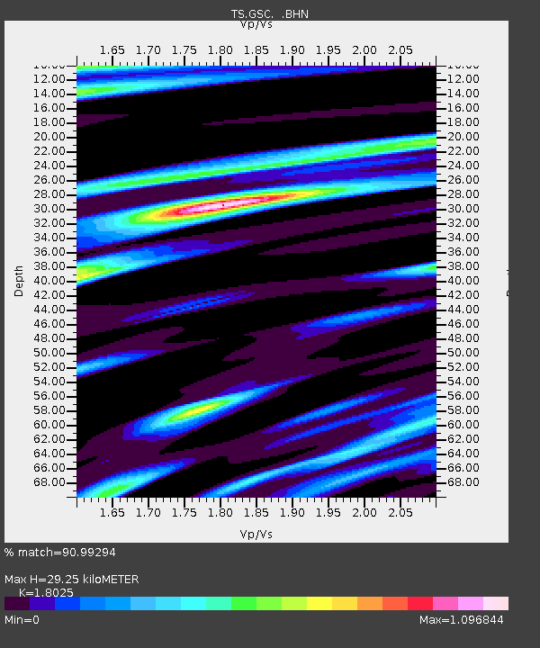
| Estimated Moho Depth: |
29.25 km |
| Estimated Crust Vp/Vs: |
1.80 |
| Assumed Crust Vp: |
6.276 km/s |
| Estimated Crust Vs: |
3.482 km/s |
| Estimated Crust Poisson's Ratio: |
0.28 |
|
| Radial Match: |
90.99294 % |
| Radial Bump: |
400 |
| Transverse Match: |
81.79604 % |
| Transverse Bump: |
400 |
| SOD ConfigId: |
16938 |
| Insert Time: |
2010-02-26 14:15:00.238 +0000 |
| GWidth: |
2.5 |
| Max Bumps: |
400 |
| Tol: |
0.001 |
|

Signal To Noise
| Channel | StoN | STA | LTA |
| TS:GSC: :BHN:19910221T02:43:13.001013Z | 2.8638015 | 3.8438608E-7 | 1.3422232E-7 |
| TS:GSC: :BHE:19910221T02:43:13.001013Z | 1.3197377 | 2.068712E-7 | 1.5675177E-7 |
| TS:GSC: :BHZ:19910221T02:43:13.001013Z | 3.3234177 | 5.027598E-7 | 1.5127794E-7 |
| Arrivals |
| Ps | 4.0 SECOND |
| PpPs | 12 SECOND |
| PsPs/PpSs | 16 SECOND |


