You are here: Home > Network List > TA - USArray Transportable Network (new EarthScope stations) Stations List
> Station M26K Nabesna, AK, USA > Earthquake Result Viewer
M26K Nabesna, AK, USA - Earthquake Result Viewer
| Earthquake location: |
Southeast Of Honshu, Japan |
| Earthquake latitude/longitude: |
29.1/139.3 |
| Earthquake time(UTC): |
2019/06/04 (155) 04:39:17 GMT |
| Earthquake Depth: |
430 km |
| Earthquake Magnitude: |
6.3 Mww |
| Earthquake Catalog/Contributor: |
NEIC PDE/us |
|
| Network: |
TA USArray Transportable Network (new EarthScope stations) |
| Station: |
M26K Nabesna, AK, USA |
| Lat/Lon: |
62.40 N/143.00 W |
| Elevation: |
888 m |
|
| Distance: |
59.0 deg |
| Az: |
32.05 deg |
| Baz: |
274.023 deg |
| Ray Param: |
0.060846377 |
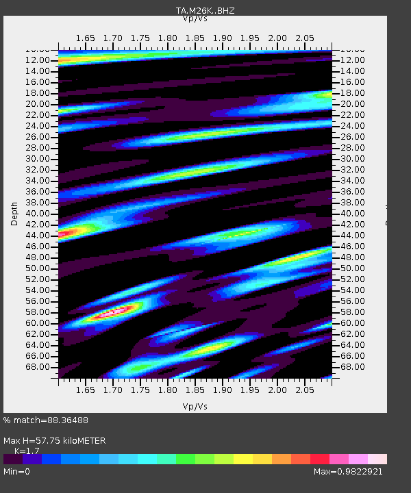
| Estimated Moho Depth: |
57.75 km |
| Estimated Crust Vp/Vs: |
1.70 |
| Assumed Crust Vp: |
6.566 km/s |
| Estimated Crust Vs: |
3.862 km/s |
| Estimated Crust Poisson's Ratio: |
0.24 |
|
| Radial Match: |
88.36488 % |
| Radial Bump: |
400 |
| Transverse Match: |
83.23516 % |
| Transverse Bump: |
400 |
| SOD ConfigId: |
18369291 |
| Insert Time: |
2019-06-18 04:48:41.766 +0000 |
| GWidth: |
2.5 |
| Max Bumps: |
400 |
| Tol: |
0.001 |
|

Signal To Noise
| Channel | StoN | STA | LTA |
| TA:M26K: :BHZ:20190604T04:48:03.750023Z | 82.725075 | 4.253682E-6 | 5.14195E-8 |
| TA:M26K: :BHN:20190604T04:48:03.750023Z | 52.19938 | 1.1717941E-6 | 2.244843E-8 |
| TA:M26K: :BHE:20190604T04:48:03.750023Z | 46.87381 | 1.7847138E-6 | 3.8074862E-8 |
| Arrivals |
| Ps | 6.5 SECOND |
| PpPs | 23 SECOND |
| PsPs/PpSs | 29 SECOND |


