You are here: Home > Network List > TA - USArray Transportable Network (new EarthScope stations) Stations List
> Station N16K Nishlik Lake, AK, USA > Earthquake Result Viewer
N16K Nishlik Lake, AK, USA - Earthquake Result Viewer
| Earthquake location: |
Southeast Of Honshu, Japan |
| Earthquake latitude/longitude: |
29.1/139.3 |
| Earthquake time(UTC): |
2019/06/04 (155) 04:39:17 GMT |
| Earthquake Depth: |
430 km |
| Earthquake Magnitude: |
6.3 Mww |
| Earthquake Catalog/Contributor: |
NEIC PDE/us |
|
| Network: |
TA USArray Transportable Network (new EarthScope stations) |
| Station: |
N16K Nishlik Lake, AK, USA |
| Lat/Lon: |
60.47 N/158.77 W |
| Elevation: |
582 m |
|
| Distance: |
51.4 deg |
| Az: |
34.004 deg |
| Baz: |
261.287 deg |
| Ray Param: |
0.06564044 |
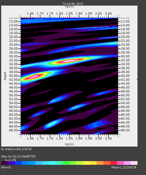
| Estimated Moho Depth: |
32.0 km |
| Estimated Crust Vp/Vs: |
1.85 |
| Assumed Crust Vp: |
6.276 km/s |
| Estimated Crust Vs: |
3.392 km/s |
| Estimated Crust Poisson's Ratio: |
0.29 |
|
| Radial Match: |
94.43476 % |
| Radial Bump: |
376 |
| Transverse Match: |
87.996475 % |
| Transverse Bump: |
400 |
| SOD ConfigId: |
18369291 |
| Insert Time: |
2019-06-18 04:48:45.127 +0000 |
| GWidth: |
2.5 |
| Max Bumps: |
400 |
| Tol: |
0.001 |
|

Signal To Noise
| Channel | StoN | STA | LTA |
| TA:N16K: :BHZ:20190604T04:47:10.224999Z | 190.3872 | 1.07312635E-5 | 5.6365465E-8 |
| TA:N16K: :BHN:20190604T04:47:10.224999Z | 37.98718 | 1.9136548E-6 | 5.0376336E-8 |
| TA:N16K: :BHE:20190604T04:47:10.224999Z | 128.71419 | 6.291542E-6 | 4.8879937E-8 |
| Arrivals |
| Ps | 4.6 SECOND |
| PpPs | 14 SECOND |
| PsPs/PpSs | 18 SECOND |


