You are here: Home > Network List > TA - USArray Transportable Network (new EarthScope stations) Stations List
> Station O28M Mount Upton, YT, CAN > Earthquake Result Viewer
O28M Mount Upton, YT, CAN - Earthquake Result Viewer

| Earthquake location: |
Southeast Of Honshu, Japan |
| Earthquake latitude/longitude: |
29.1/139.3 |
| Earthquake time(UTC): |
2019/06/04 (155) 04:39:17 GMT |
| Earthquake Depth: |
430 km |
| Earthquake Magnitude: |
6.3 Mww |
| Earthquake Catalog/Contributor: |
NEIC PDE/us |
|
| Network: |
TA USArray Transportable Network (new EarthScope stations) |
| Station: |
O28M Mount Upton, YT, CAN |
| Lat/Lon: |
60.77 N/140.19 W |
| Elevation: |
2622 m |
|
| Distance: |
60.5 deg |
| Az: |
33.779 deg |
| Baz: |
277.358 deg |
| Ray Param: |
0.059908904 |
| Estimated Moho Depth: |
45.0 km |
| Estimated Crust Vp/Vs: |
1.91 |
| Assumed Crust Vp: |
6.566 km/s |
| Estimated Crust Vs: |
3.433 km/s |
| Estimated Crust Poisson's Ratio: |
0.31 |
|
| Radial Match: |
93.25571 % |
| Radial Bump: |
400 |
| Transverse Match: |
85.15642 % |
| Transverse Bump: |
400 |
| SOD ConfigId: |
18369291 |
| Insert Time: |
2019-06-18 04:48:54.382 +0000 |
| GWidth: |
2.5 |
| Max Bumps: |
400 |
| Tol: |
0.001 |
|
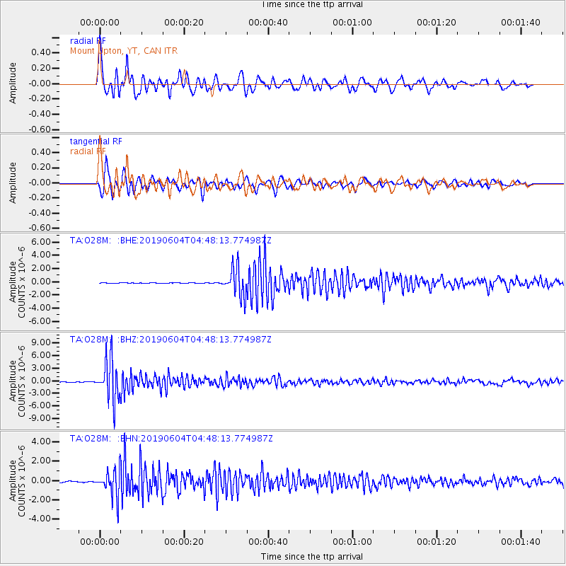
Signal To Noise
| Channel | StoN | STA | LTA |
| TA:O28M: :BHZ:20190604T04:48:13.774987Z | 61.64751 | 4.9559317E-6 | 8.039143E-8 |
| TA:O28M: :BHN:20190604T04:48:13.774987Z | 22.671227 | 1.3775395E-6 | 6.076158E-8 |
| TA:O28M: :BHE:20190604T04:48:13.774987Z | 47.81123 | 2.1938329E-6 | 4.5885304E-8 |
| Arrivals |
| Ps | 6.5 SECOND |
| PpPs | 19 SECOND |
| PsPs/PpSs | 26 SECOND |


