You are here: Home > Network List > TA - USArray Transportable Network (new EarthScope stations) Stations List
> Station P17K Kvichak River, AK, USA > Earthquake Result Viewer
P17K Kvichak River, AK, USA - Earthquake Result Viewer
| Earthquake location: |
Southeast Of Honshu, Japan |
| Earthquake latitude/longitude: |
29.1/139.3 |
| Earthquake time(UTC): |
2019/06/04 (155) 04:39:17 GMT |
| Earthquake Depth: |
430 km |
| Earthquake Magnitude: |
6.3 Mww |
| Earthquake Catalog/Contributor: |
NEIC PDE/us |
|
| Network: |
TA USArray Transportable Network (new EarthScope stations) |
| Station: |
P17K Kvichak River, AK, USA |
| Lat/Lon: |
59.20 N/156.44 W |
| Elevation: |
91 m |
|
| Distance: |
52.4 deg |
| Az: |
35.807 deg |
| Baz: |
264.41 deg |
| Ray Param: |
0.065018095 |
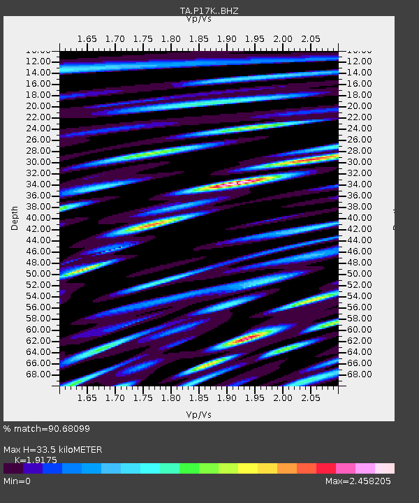
| Estimated Moho Depth: |
33.5 km |
| Estimated Crust Vp/Vs: |
1.92 |
| Assumed Crust Vp: |
6.276 km/s |
| Estimated Crust Vs: |
3.273 km/s |
| Estimated Crust Poisson's Ratio: |
0.31 |
|
| Radial Match: |
90.68099 % |
| Radial Bump: |
400 |
| Transverse Match: |
91.08397 % |
| Transverse Bump: |
400 |
| SOD ConfigId: |
18369291 |
| Insert Time: |
2019-06-18 04:48:56.731 +0000 |
| GWidth: |
2.5 |
| Max Bumps: |
400 |
| Tol: |
0.001 |
|
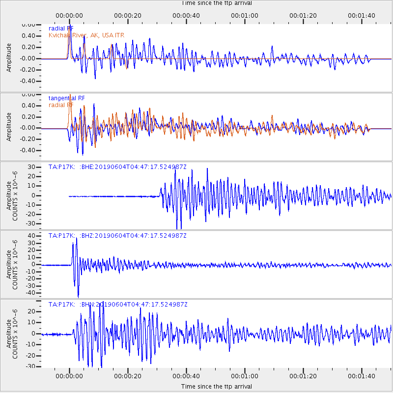
Signal To Noise
| Channel | StoN | STA | LTA |
| TA:P17K: :BHZ:20190604T04:47:17.524987Z | 124.43497 | 1.779983E-5 | 1.4304524E-7 |
| TA:P17K: :BHN:20190604T04:47:17.524987Z | 36.15958 | 8.939968E-6 | 2.472365E-7 |
| TA:P17K: :BHE:20190604T04:47:17.524987Z | 36.35684 | 6.580139E-6 | 1.8098766E-7 |
| Arrivals |
| Ps | 5.1 SECOND |
| PpPs | 15 SECOND |
| PsPs/PpSs | 20 SECOND |


