You are here: Home > Network List > TA - USArray Transportable Network (new EarthScope stations) Stations List
> Station P18K Big Mountain, AK, USA > Earthquake Result Viewer
P18K Big Mountain, AK, USA - Earthquake Result Viewer
| Earthquake location: |
Southeast Of Honshu, Japan |
| Earthquake latitude/longitude: |
29.1/139.3 |
| Earthquake time(UTC): |
2019/06/04 (155) 04:39:17 GMT |
| Earthquake Depth: |
430 km |
| Earthquake Magnitude: |
6.3 Mww |
| Earthquake Catalog/Contributor: |
NEIC PDE/us |
|
| Network: |
TA USArray Transportable Network (new EarthScope stations) |
| Station: |
P18K Big Mountain, AK, USA |
| Lat/Lon: |
59.39 N/155.23 W |
| Elevation: |
680 m |
|
| Distance: |
53.0 deg |
| Az: |
35.63 deg |
| Baz: |
265.341 deg |
| Ray Param: |
0.06461592 |
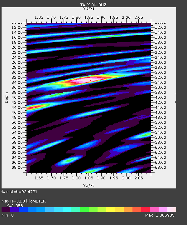
| Estimated Moho Depth: |
33.0 km |
| Estimated Crust Vp/Vs: |
1.86 |
| Assumed Crust Vp: |
6.438 km/s |
| Estimated Crust Vs: |
3.471 km/s |
| Estimated Crust Poisson's Ratio: |
0.30 |
|
| Radial Match: |
93.4731 % |
| Radial Bump: |
400 |
| Transverse Match: |
89.4847 % |
| Transverse Bump: |
400 |
| SOD ConfigId: |
18369291 |
| Insert Time: |
2019-06-18 04:48:57.696 +0000 |
| GWidth: |
2.5 |
| Max Bumps: |
400 |
| Tol: |
0.001 |
|

Signal To Noise
| Channel | StoN | STA | LTA |
| TA:P18K: :BHZ:20190604T04:47:22.099999Z | 146.10931 | 7.999291E-6 | 5.474867E-8 |
| TA:P18K: :BHN:20190604T04:47:22.099999Z | 36.50942 | 1.6106491E-6 | 4.411599E-8 |
| TA:P18K: :BHE:20190604T04:47:22.099999Z | 65.02058 | 3.2235205E-6 | 4.9576933E-8 |
| Arrivals |
| Ps | 4.6 SECOND |
| PpPs | 14 SECOND |
| PsPs/PpSs | 19 SECOND |


