You are here: Home > Network List > UO - University of Oregon Regional Network Stations List
> Station MARQ Marquam, OR, USA > Earthquake Result Viewer
MARQ Marquam, OR, USA - Earthquake Result Viewer
| Earthquake location: |
Southeast Of Honshu, Japan |
| Earthquake latitude/longitude: |
29.1/139.3 |
| Earthquake time(UTC): |
2019/06/04 (155) 04:39:17 GMT |
| Earthquake Depth: |
430 km |
| Earthquake Magnitude: |
6.3 Mww |
| Earthquake Catalog/Contributor: |
NEIC PDE/us |
|
| Network: |
UO University of Oregon Regional Network |
| Station: |
MARQ Marquam, OR, USA |
| Lat/Lon: |
45.07 N/122.67 W |
| Elevation: |
159 m |
|
| Distance: |
75.3 deg |
| Az: |
46.514 deg |
| Baz: |
296.322 deg |
| Ray Param: |
0.050495893 |
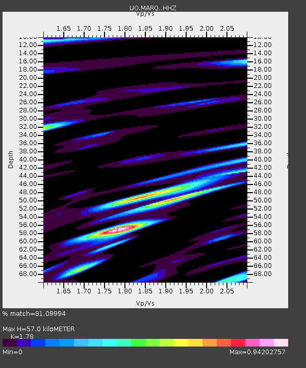
| Estimated Moho Depth: |
57.0 km |
| Estimated Crust Vp/Vs: |
1.78 |
| Assumed Crust Vp: |
6.566 km/s |
| Estimated Crust Vs: |
3.689 km/s |
| Estimated Crust Poisson's Ratio: |
0.27 |
|
| Radial Match: |
81.09994 % |
| Radial Bump: |
400 |
| Transverse Match: |
75.90123 % |
| Transverse Bump: |
400 |
| SOD ConfigId: |
18369291 |
| Insert Time: |
2019-06-18 04:49:46.827 +0000 |
| GWidth: |
2.5 |
| Max Bumps: |
400 |
| Tol: |
0.001 |
|

Signal To Noise
| Channel | StoN | STA | LTA |
| UO:MARQ: :HHZ:20190604T04:49:43.969994Z | 32.757736 | 7.770184E-6 | 2.3720152E-7 |
| UO:MARQ: :HHN:20190604T04:49:43.969994Z | 9.173388 | 1.1720141E-6 | 1.277624E-7 |
| UO:MARQ: :HHE:20190604T04:49:43.969994Z | 18.517912 | 2.075177E-6 | 1.12063226E-7 |
| Arrivals |
| Ps | 7.0 SECOND |
| PpPs | 23 SECOND |
| PsPs/PpSs | 30 SECOND |


