You are here: Home > Network List > UU - University of Utah Regional Network Stations List
> Station GAWY Genesis Alkali Granger, WY, USA > Earthquake Result Viewer
GAWY Genesis Alkali Granger, WY, USA - Earthquake Result Viewer
| Earthquake location: |
Southeast Of Honshu, Japan |
| Earthquake latitude/longitude: |
29.1/139.3 |
| Earthquake time(UTC): |
2019/06/04 (155) 04:39:17 GMT |
| Earthquake Depth: |
430 km |
| Earthquake Magnitude: |
6.3 Mww |
| Earthquake Catalog/Contributor: |
NEIC PDE/us |
|
| Network: |
UU University of Utah Regional Network |
| Station: |
GAWY Genesis Alkali Granger, WY, USA |
| Lat/Lon: |
41.74 N/109.85 W |
| Elevation: |
2011 m |
|
| Distance: |
85.0 deg |
| Az: |
44.591 deg |
| Baz: |
304.79 deg |
| Ray Param: |
0.043930367 |
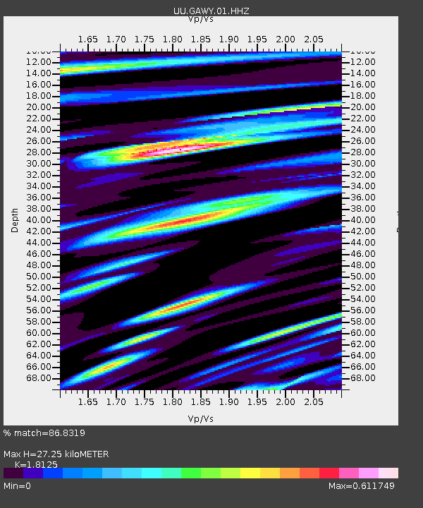
| Estimated Moho Depth: |
27.25 km |
| Estimated Crust Vp/Vs: |
1.81 |
| Assumed Crust Vp: |
6.207 km/s |
| Estimated Crust Vs: |
3.425 km/s |
| Estimated Crust Poisson's Ratio: |
0.28 |
|
| Radial Match: |
86.8319 % |
| Radial Bump: |
400 |
| Transverse Match: |
87.1019 % |
| Transverse Bump: |
400 |
| SOD ConfigId: |
18369291 |
| Insert Time: |
2019-06-18 04:50:18.819 +0000 |
| GWidth: |
2.5 |
| Max Bumps: |
400 |
| Tol: |
0.001 |
|

Signal To Noise
| Channel | StoN | STA | LTA |
| UU:GAWY:01:HHZ:20190604T04:50:34.899987Z | 59.83707 | 1.960333E-7 | 3.276118E-9 |
| UU:GAWY:01:HHN:20190604T04:50:34.899987Z | 4.5551786 | 1.0165665E-9 | 2.231672E-10 |
| UU:GAWY:01:HHE:20190604T04:50:34.899987Z | 29.083279 | 9.045966E-8 | 3.1103666E-9 |
| Arrivals |
| Ps | 3.6 SECOND |
| PpPs | 12 SECOND |
| PsPs/PpSs | 16 SECOND |


