You are here: Home > Network List > UW - Pacific Northwest Regional Seismic Network Stations List
> Station H2O H2O, Hanford, WA, USA > Earthquake Result Viewer
H2O H2O, Hanford, WA, USA - Earthquake Result Viewer
| Earthquake location: |
Southeast Of Honshu, Japan |
| Earthquake latitude/longitude: |
29.1/139.3 |
| Earthquake time(UTC): |
2019/06/04 (155) 04:39:17 GMT |
| Earthquake Depth: |
430 km |
| Earthquake Magnitude: |
6.3 Mww |
| Earthquake Catalog/Contributor: |
NEIC PDE/us |
|
| Network: |
UW Pacific Northwest Regional Seismic Network |
| Station: |
H2O H2O, Hanford, WA, USA |
| Lat/Lon: |
46.40 N/119.42 W |
| Elevation: |
175 m |
|
| Distance: |
76.7 deg |
| Az: |
44.224 deg |
| Baz: |
298.083 deg |
| Ray Param: |
0.0495639 |
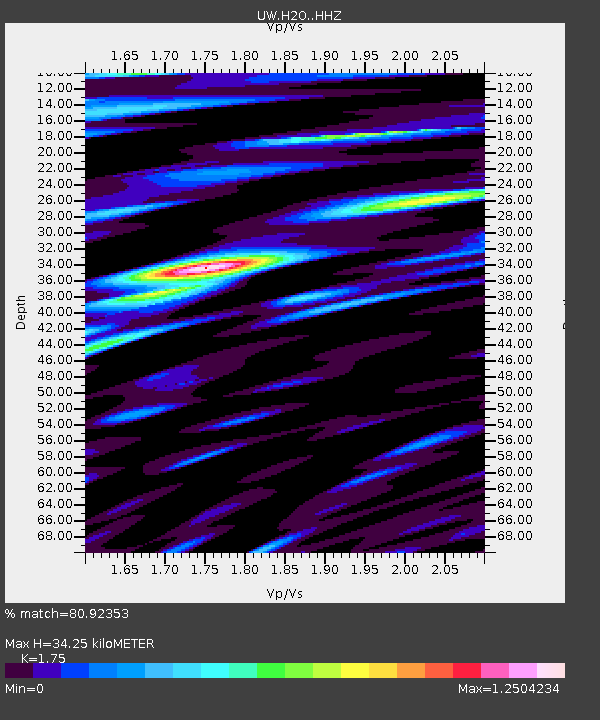
| Estimated Moho Depth: |
34.25 km |
| Estimated Crust Vp/Vs: |
1.75 |
| Assumed Crust Vp: |
6.419 km/s |
| Estimated Crust Vs: |
3.668 km/s |
| Estimated Crust Poisson's Ratio: |
0.26 |
|
| Radial Match: |
80.92353 % |
| Radial Bump: |
400 |
| Transverse Match: |
66.272835 % |
| Transverse Bump: |
400 |
| SOD ConfigId: |
18369291 |
| Insert Time: |
2019-06-18 04:50:35.628 +0000 |
| GWidth: |
2.5 |
| Max Bumps: |
400 |
| Tol: |
0.001 |
|

Signal To Noise
| Channel | StoN | STA | LTA |
| UW:H2O: :HHZ:20190604T04:49:51.810021Z | 49.211933 | 4.355932E-6 | 8.8513744E-8 |
| UW:H2O: :HHN:20190604T04:49:51.810021Z | 19.644384 | 1.940472E-6 | 9.877998E-8 |
| UW:H2O: :HHE:20190604T04:49:51.810021Z | 43.888466 | 2.6084545E-6 | 5.943371E-8 |
| Arrivals |
| Ps | 4.1 SECOND |
| PpPs | 14 SECOND |
| PsPs/PpSs | 18 SECOND |


