You are here: Home > Network List > WY - Yellowstone Wyoming Seismic Network Stations List
> Station YHH Holmes Hill, YNP, WY, USA > Earthquake Result Viewer
YHH Holmes Hill, YNP, WY, USA - Earthquake Result Viewer
| Earthquake location: |
Southeast Of Honshu, Japan |
| Earthquake latitude/longitude: |
29.1/139.3 |
| Earthquake time(UTC): |
2019/06/04 (155) 04:39:17 GMT |
| Earthquake Depth: |
430 km |
| Earthquake Magnitude: |
6.3 Mww |
| Earthquake Catalog/Contributor: |
NEIC PDE/us |
|
| Network: |
WY Yellowstone Wyoming Seismic Network |
| Station: |
YHH Holmes Hill, YNP, WY, USA |
| Lat/Lon: |
44.79 N/110.85 W |
| Elevation: |
2717 m |
|
| Distance: |
82.7 deg |
| Az: |
42.474 deg |
| Baz: |
303.88 deg |
| Ray Param: |
0.045542873 |
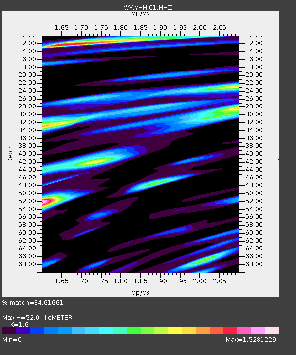
| Estimated Moho Depth: |
52.0 km |
| Estimated Crust Vp/Vs: |
1.60 |
| Assumed Crust Vp: |
6.35 km/s |
| Estimated Crust Vs: |
3.969 km/s |
| Estimated Crust Poisson's Ratio: |
0.18 |
|
| Radial Match: |
84.61661 % |
| Radial Bump: |
400 |
| Transverse Match: |
75.35992 % |
| Transverse Bump: |
400 |
| SOD ConfigId: |
18369291 |
| Insert Time: |
2019-06-18 04:50:59.341 +0000 |
| GWidth: |
2.5 |
| Max Bumps: |
400 |
| Tol: |
0.001 |
|
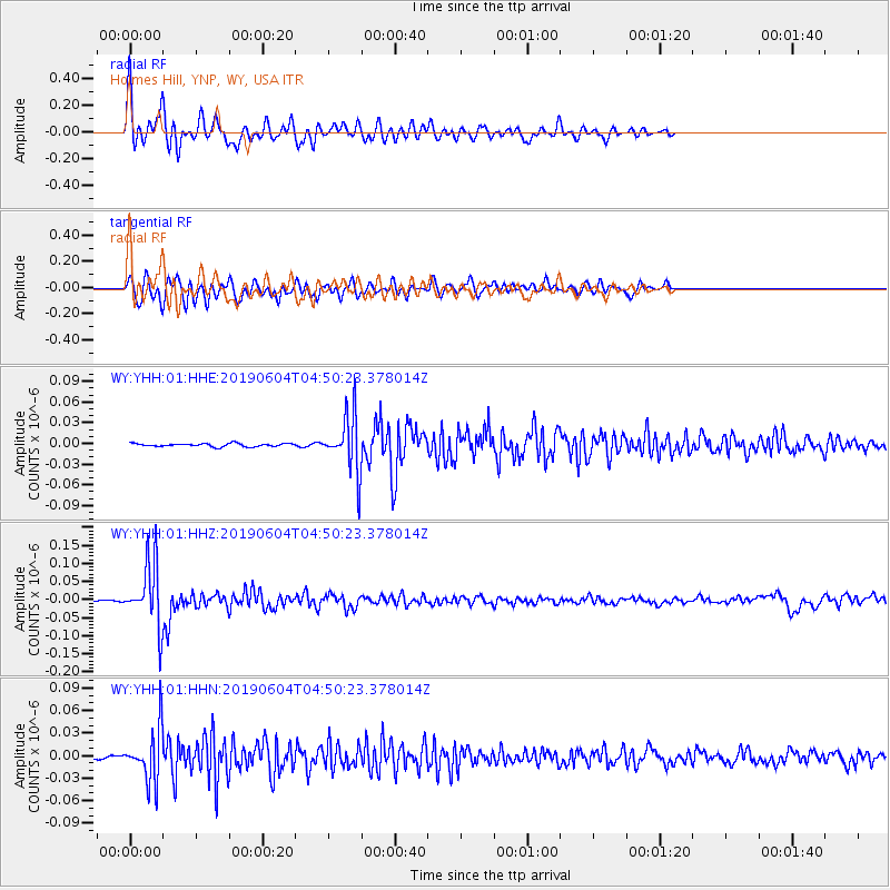
Signal To Noise
| Channel | StoN | STA | LTA |
| WY:YHH:01:HHZ:20190604T04:50:23.378014Z | 50.288628 | 8.6332726E-8 | 1.7167445E-9 |
| WY:YHH:01:HHN:20190604T04:50:23.378014Z | 18.18913 | 3.52882E-8 | 1.9400708E-9 |
| WY:YHH:01:HHE:20190604T04:50:23.378014Z | 18.05737 | 4.0875467E-8 | 2.2636448E-9 |
| Arrivals |
| Ps | 5.0 SECOND |
| PpPs | 21 SECOND |
| PsPs/PpSs | 26 SECOND |


