You are here: Home > Network List > WY - Yellowstone Wyoming Seismic Network Stations List
> Station YNR Norris Junction, YNP, WY, USA > Earthquake Result Viewer
YNR Norris Junction, YNP, WY, USA - Earthquake Result Viewer
| Earthquake location: |
Southeast Of Honshu, Japan |
| Earthquake latitude/longitude: |
29.1/139.3 |
| Earthquake time(UTC): |
2019/06/04 (155) 04:39:17 GMT |
| Earthquake Depth: |
430 km |
| Earthquake Magnitude: |
6.3 Mww |
| Earthquake Catalog/Contributor: |
NEIC PDE/us |
|
| Network: |
WY Yellowstone Wyoming Seismic Network |
| Station: |
YNR Norris Junction, YNP, WY, USA |
| Lat/Lon: |
44.72 N/110.68 W |
| Elevation: |
2336 m |
|
| Distance: |
82.8 deg |
| Az: |
42.466 deg |
| Baz: |
303.999 deg |
| Ray Param: |
0.04544394 |
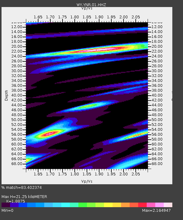
| Estimated Moho Depth: |
21.25 km |
| Estimated Crust Vp/Vs: |
1.89 |
| Assumed Crust Vp: |
6.35 km/s |
| Estimated Crust Vs: |
3.364 km/s |
| Estimated Crust Poisson's Ratio: |
0.30 |
|
| Radial Match: |
83.402374 % |
| Radial Bump: |
400 |
| Transverse Match: |
74.84375 % |
| Transverse Bump: |
400 |
| SOD ConfigId: |
18369291 |
| Insert Time: |
2019-06-18 04:51:02.797 +0000 |
| GWidth: |
2.5 |
| Max Bumps: |
400 |
| Tol: |
0.001 |
|

Signal To Noise
| Channel | StoN | STA | LTA |
| WY:YNR:01:HHZ:20190604T04:50:24.097985Z | 45.246204 | 1.0169217E-7 | 2.2475293E-9 |
| WY:YNR:01:HHN:20190604T04:50:24.097985Z | 7.449666 | 1.8525078E-8 | 2.486699E-9 |
| WY:YNR:01:HHE:20190604T04:50:24.097985Z | 8.7470875 | 2.0921206E-8 | 2.3917912E-9 |
| Arrivals |
| Ps | 3.0 SECOND |
| PpPs | 9.4 SECOND |
| PsPs/PpSs | 12 SECOND |


