You are here: Home > Network List > TA - USArray Transportable Network (new EarthScope stations) Stations List
> Station D08A Wollman Farm, Schrag, WA, USA > Earthquake Result Viewer
D08A Wollman Farm, Schrag, WA, USA - Earthquake Result Viewer
| Earthquake location: |
Near Coast Of Peru |
| Earthquake latitude/longitude: |
-14.3/-76.1 |
| Earthquake time(UTC): |
2007/08/16 (228) 05:16:56 GMT |
| Earthquake Depth: |
23 km |
| Earthquake Magnitude: |
5.8 MB, 6.1 MS, 6.3 MW, 6.2 ML |
| Earthquake Catalog/Contributor: |
WHDF/NEIC |
|
| Network: |
TA USArray Transportable Network (new EarthScope stations) |
| Station: |
D08A Wollman Farm, Schrag, WA, USA |
| Lat/Lon: |
47.06 N/118.92 W |
| Elevation: |
385 m |
|
| Distance: |
72.1 deg |
| Az: |
330.781 deg |
| Baz: |
136.198 deg |
| Ray Param: |
0.0538644 |
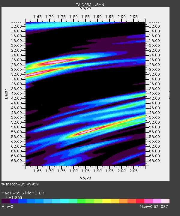
| Estimated Moho Depth: |
55.5 km |
| Estimated Crust Vp/Vs: |
1.86 |
| Assumed Crust Vp: |
6.419 km/s |
| Estimated Crust Vs: |
3.461 km/s |
| Estimated Crust Poisson's Ratio: |
0.30 |
|
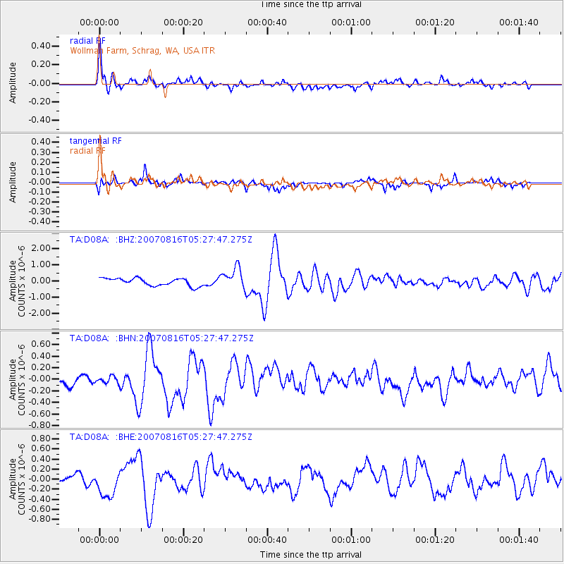
| Radial Match: |
85.99959 % |
| Radial Bump: |
400 |
| Transverse Match: |
71.9395 % |
| Transverse Bump: |
400 |
| SOD ConfigId: |
2564 |
| Insert Time: |
2010-03-06 23:23:12.602 +0000 |
| GWidth: |
2.5 |
| Max Bumps: |
400 |
| Tol: |
0.001 |
|
Signal To Noise
| Channel | StoN | STA | LTA |
| TA:D08A: :BHN:20070816T05:27:47.275Z | 0.50011724 | 6.3315795E-8 | 1.266019E-7 |
| TA:D08A: :BHE:20070816T05:27:47.275Z | 3.1624224 | 2.7308673E-7 | 8.635365E-8 |
| TA:D08A: :BHZ:20070816T05:27:47.275Z | 2.9008625 | 6.766292E-7 | 2.3325106E-7 |
| Arrivals |
| Ps | 7.6 SECOND |
| PpPs | 24 SECOND |
| PsPs/PpSs | 32 SECOND |


