You are here: Home > Network List > TA - USArray Transportable Network (new EarthScope stations) Stations List
> Station D08A Wollman Farm, Schrag, WA, USA > Earthquake Result Viewer
D08A Wollman Farm, Schrag, WA, USA - Earthquake Result Viewer

| Earthquake location: |
Andreanof Islands, Aleutian Is. |
| Earthquake latitude/longitude: |
50.2/-177.6 |
| Earthquake time(UTC): |
2007/08/16 (228) 04:03:03 GMT |
| Earthquake Depth: |
15 km |
| Earthquake Magnitude: |
5.8 MB |
| Earthquake Catalog/Contributor: |
WHDF/NEIC |
|
| Network: |
TA USArray Transportable Network (new EarthScope stations) |
| Station: |
D08A Wollman Farm, Schrag, WA, USA |
| Lat/Lon: |
47.06 N/118.92 W |
| Elevation: |
385 m |
|
| Distance: |
38.0 deg |
| Az: |
71.46 deg |
| Baz: |
297.083 deg |
| Ray Param: |
0.0757957 |
| Estimated Moho Depth: |
56.25 km |
| Estimated Crust Vp/Vs: |
1.85 |
| Assumed Crust Vp: |
6.419 km/s |
| Estimated Crust Vs: |
3.479 km/s |
| Estimated Crust Poisson's Ratio: |
0.29 |
|
| Radial Match: |
82.391525 % |
| Radial Bump: |
308 |
| Transverse Match: |
70.99003 % |
| Transverse Bump: |
400 |
| SOD ConfigId: |
2564 |
| Insert Time: |
2010-03-06 23:23:14.869 +0000 |
| GWidth: |
2.5 |
| Max Bumps: |
400 |
| Tol: |
0.001 |
|
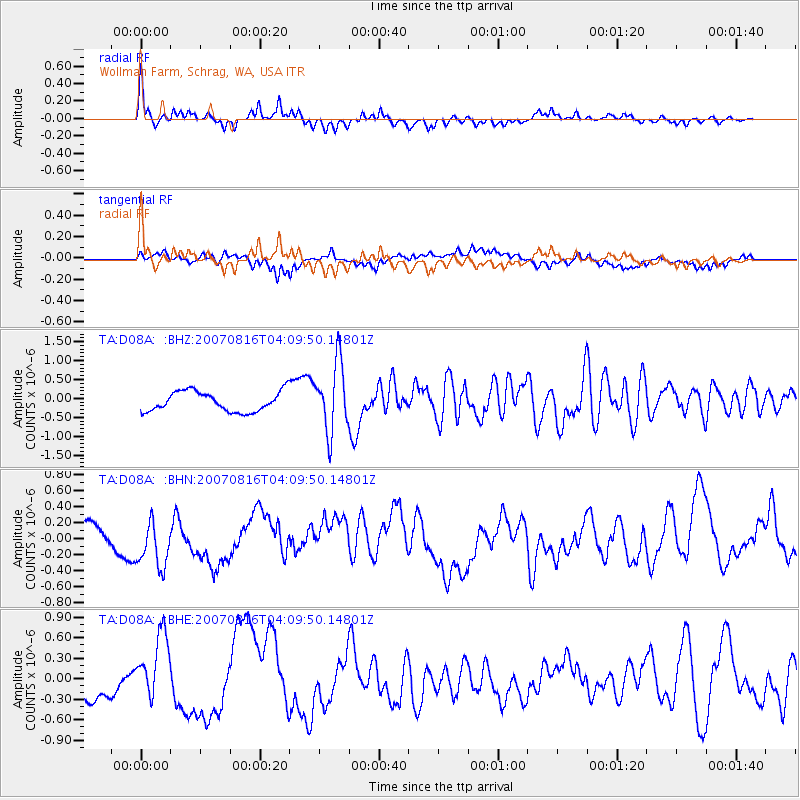
Signal To Noise
| Channel | StoN | STA | LTA |
| TA:D08A: :BHN:20070816T04:09:50.14801Z | 3.3542178 | 3.0540122E-7 | 9.1049905E-8 |
| TA:D08A: :BHE:20070816T04:09:50.14801Z | 2.3476837 | 4.815482E-7 | 2.0511632E-7 |
| TA:D08A: :BHZ:20070816T04:09:50.14801Z | 3.4613075 | 9.093028E-7 | 2.62705E-7 |
| Arrivals |
| Ps | 7.9 SECOND |
| PpPs | 23 SECOND |
| PsPs/PpSs | 31 SECOND |


