You are here: Home > Network List > TA - USArray Transportable Network (new EarthScope stations) Stations List
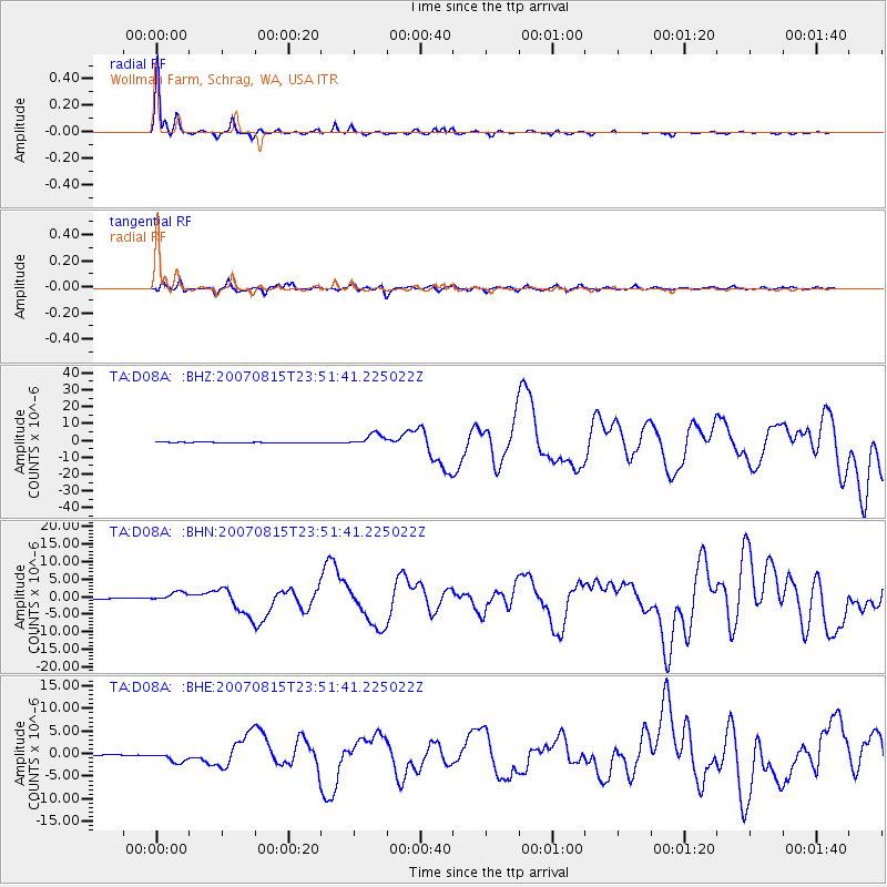
> Station D08A Wollman Farm, Schrag, WA, USA > Earthquake Result Viewer
D08A Wollman Farm, Schrag, WA, USA - Earthquake Result Viewer
| Earthquake location: |
Near Coast Of Peru |
| Earthquake latitude/longitude: |
-13.4/-76.6 |
| Earthquake time(UTC): |
2007/08/15 (227) 23:40:57 GMT |
| Earthquake Depth: |
39 km |
| Earthquake Magnitude: |
6.7 MB, 7.9 MS, 8.0 MW, 7.5 ME |
| Earthquake Catalog/Contributor: |
WHDF/NEIC |
|
| Network: |
TA USArray Transportable Network (new EarthScope stations) |
| Station: |
D08A Wollman Farm, Schrag, WA, USA |
| Lat/Lon: |
47.06 N/118.92 W |
| Elevation: |
385 m |
|
| Distance: |
71.1 deg |
| Az: |
330.884 deg |
| Baz: |
136.166 deg |
| Ray Param: |
0.0544893 |
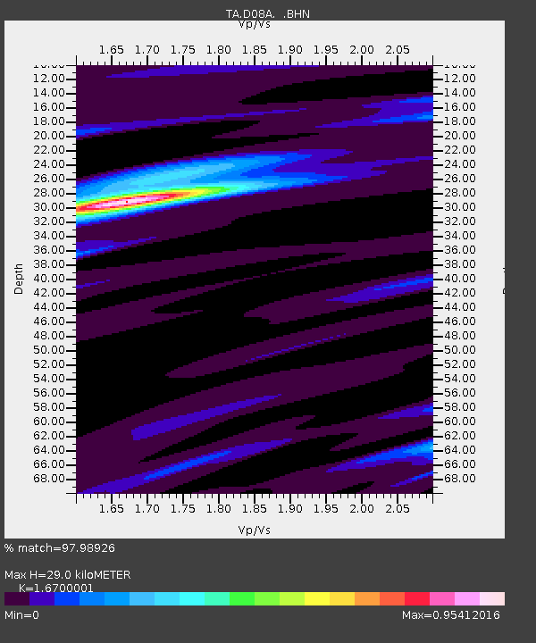
| Estimated Moho Depth: |
29.0 km |
| Estimated Crust Vp/Vs: |
1.67 |
| Assumed Crust Vp: |
6.419 km/s |
| Estimated Crust Vs: |
3.844 km/s |
| Estimated Crust Poisson's Ratio: |
0.22 |
|
| Radial Match: |
97.98926 % |
| Radial Bump: |
260 |
| Transverse Match: |
88.613365 % |
| Transverse Bump: |
400 |
| SOD ConfigId: |
2564 |
| Insert Time: |
2010-03-06 23:23:18.965 +0000 |
| GWidth: |
2.5 |
| Max Bumps: |
400 |
| Tol: |
0.001 |
|
Signal To Noise
| Channel | StoN | STA | LTA |
| TA:D08A: :BHN:20070815T23:51:41.225022Z | 15.597312 | 1.2625651E-6 | 8.094761E-8 |
| TA:D08A: :BHE:20070815T23:51:41.225022Z | 15.4972 | 1.1240185E-6 | 7.2530426E-8 |
| TA:D08A: :BHZ:20070815T23:51:41.225022Z | 29.676035 | 3.5033474E-6 | 1.1805309E-7 |
| Arrivals |
| Ps | 3.1 SECOND |
| PpPs | 12 SECOND |
| PsPs/PpSs | 15 SECOND |


