You are here: Home > Network List > TA - USArray Transportable Network (new EarthScope stations) Stations List
> Station D08A Wollman Farm, Schrag, WA, USA > Earthquake Result Viewer
D08A Wollman Farm, Schrag, WA, USA - Earthquake Result Viewer
| Earthquake location: |
Komandorskiye Ostrova Region |
| Earthquake latitude/longitude: |
53.6/169.7 |
| Earthquake time(UTC): |
2007/07/29 (210) 04:54:36 GMT |
| Earthquake Depth: |
26 km |
| Earthquake Magnitude: |
6.0 MB, 5.5 MS, 5.9 MW, 5.8 MW |
| Earthquake Catalog/Contributor: |
WHDF/NEIC |
|
| Network: |
TA USArray Transportable Network (new EarthScope stations) |
| Station: |
D08A Wollman Farm, Schrag, WA, USA |
| Lat/Lon: |
47.06 N/118.92 W |
| Elevation: |
385 m |
|
| Distance: |
44.3 deg |
| Az: |
68.204 deg |
| Baz: |
306.04 deg |
| Ray Param: |
0.071989335 |
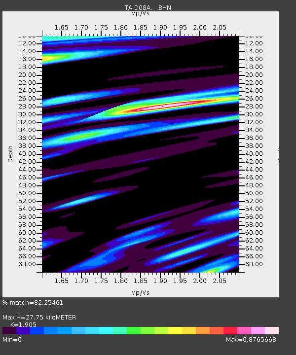
| Estimated Moho Depth: |
27.75 km |
| Estimated Crust Vp/Vs: |
1.90 |
| Assumed Crust Vp: |
6.419 km/s |
| Estimated Crust Vs: |
3.37 km/s |
| Estimated Crust Poisson's Ratio: |
0.31 |
|
| Radial Match: |
82.25461 % |
| Radial Bump: |
399 |
| Transverse Match: |
72.94442 % |
| Transverse Bump: |
400 |
| SOD ConfigId: |
2564 |
| Insert Time: |
2010-03-06 23:23:24.547 +0000 |
| GWidth: |
2.5 |
| Max Bumps: |
400 |
| Tol: |
0.001 |
|

Signal To Noise
| Channel | StoN | STA | LTA |
| TA:D08A: :BHN:20070729T05:02:13.173013Z | 2.755363 | 1.2417335E-7 | 4.506606E-8 |
| TA:D08A: :BHE:20070729T05:02:13.173013Z | 3.3714833 | 1.3341052E-7 | 3.9570278E-8 |
| TA:D08A: :BHZ:20070729T05:02:13.173013Z | 2.807139 | 2.7301968E-7 | 9.725905E-8 |
| Arrivals |
| Ps | 4.2 SECOND |
| PpPs | 12 SECOND |
| PsPs/PpSs | 16 SECOND |


