You are here: Home > Network List > TA - USArray Transportable Network (new EarthScope stations) Stations List
> Station D08A Wollman Farm, Schrag, WA, USA > Earthquake Result Viewer
D08A Wollman Farm, Schrag, WA, USA - Earthquake Result Viewer
| Earthquake location: |
Near West Coast Of Honshu, Japan |
| Earthquake latitude/longitude: |
37.5/138.4 |
| Earthquake time(UTC): |
2007/07/16 (197) 01:13:22 GMT |
| Earthquake Depth: |
12 km |
| Earthquake Magnitude: |
6.5 MB, 6.4 MS, 6.6 MW, 6.5 MW |
| Earthquake Catalog/Contributor: |
WHDF/NEIC |
|
| Network: |
TA USArray Transportable Network (new EarthScope stations) |
| Station: |
D08A Wollman Farm, Schrag, WA, USA |
| Lat/Lon: |
47.06 N/118.92 W |
| Elevation: |
385 m |
|
| Distance: |
71.1 deg |
| Az: |
44.843 deg |
| Baz: |
304.926 deg |
| Ray Param: |
0.054537203 |
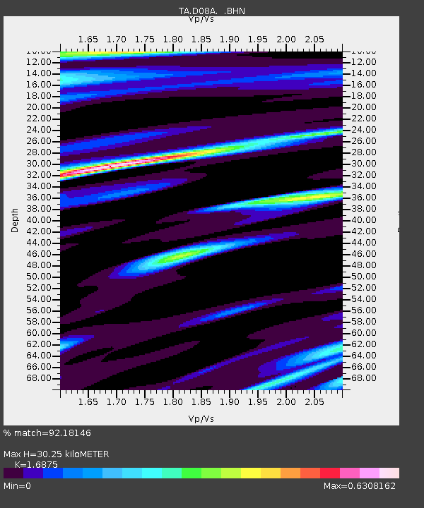
| Estimated Moho Depth: |
30.25 km |
| Estimated Crust Vp/Vs: |
1.69 |
| Assumed Crust Vp: |
6.419 km/s |
| Estimated Crust Vs: |
3.804 km/s |
| Estimated Crust Poisson's Ratio: |
0.23 |
|
| Radial Match: |
92.18146 % |
| Radial Bump: |
342 |
| Transverse Match: |
82.861305 % |
| Transverse Bump: |
400 |
| SOD ConfigId: |
2564 |
| Insert Time: |
2010-03-06 23:23:26.970 +0000 |
| GWidth: |
2.5 |
| Max Bumps: |
400 |
| Tol: |
0.001 |
|

Signal To Noise
| Channel | StoN | STA | LTA |
| TA:D08A: :BHN:20070716T01:24:09.200017Z | 11.901021 | 6.4254715E-7 | 5.3990927E-8 |
| TA:D08A: :BHE:20070716T01:24:09.200017Z | 18.783102 | 6.261741E-7 | 3.33371E-8 |
| TA:D08A: :BHZ:20070716T01:24:09.200017Z | 43.39849 | 2.7787894E-6 | 6.4029635E-8 |
| Arrivals |
| Ps | 3.4 SECOND |
| PpPs | 12 SECOND |
| PsPs/PpSs | 16 SECOND |


