You are here: Home > Network List > TA - USArray Transportable Network (new EarthScope stations) Stations List
> Station D08A Wollman Farm, Schrag, WA, USA > Earthquake Result Viewer
D08A Wollman Farm, Schrag, WA, USA - Earthquake Result Viewer

| Earthquake location: |
Samoa Islands Region |
| Earthquake latitude/longitude: |
-16.6/-172.0 |
| Earthquake time(UTC): |
2006/09/28 (271) 06:22:09 GMT |
| Earthquake Depth: |
28 km |
| Earthquake Magnitude: |
6.5 MB, 6.6 MS, 6.9 MW, 6.7 MW |
| Earthquake Catalog/Contributor: |
WHDF/NEIC |
|
| Network: |
TA USArray Transportable Network (new EarthScope stations) |
| Station: |
D08A Wollman Farm, Schrag, WA, USA |
| Lat/Lon: |
47.06 N/118.92 W |
| Elevation: |
385 m |
|
| Distance: |
79.3 deg |
| Az: |
33.821 deg |
| Baz: |
231.317 deg |
| Ray Param: |
0.049050722 |
| Estimated Moho Depth: |
28.5 km |
| Estimated Crust Vp/Vs: |
1.83 |
| Assumed Crust Vp: |
6.419 km/s |
| Estimated Crust Vs: |
3.503 km/s |
| Estimated Crust Poisson's Ratio: |
0.29 |
|
| Radial Match: |
93.569664 % |
| Radial Bump: |
266 |
| Transverse Match: |
87.815384 % |
| Transverse Bump: |
400 |
| SOD ConfigId: |
2665 |
| Insert Time: |
2010-03-06 23:23:52.382 +0000 |
| GWidth: |
2.5 |
| Max Bumps: |
400 |
| Tol: |
0.001 |
|
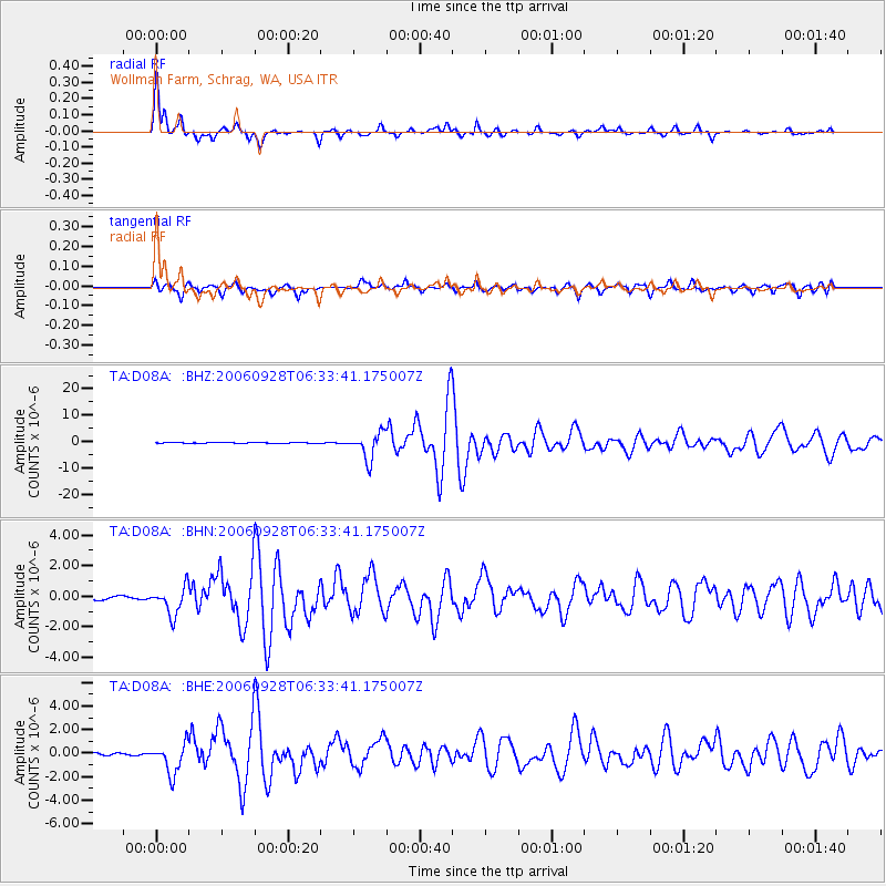
Signal To Noise
| Channel | StoN | STA | LTA |
| TA:D08A: :BHN:20060928T06:33:41.175007Z | 8.278469 | 9.146316E-7 | 1.10483185E-7 |
| TA:D08A: :BHE:20060928T06:33:41.175007Z | 8.536375 | 1.2851906E-6 | 1.5055461E-7 |
| TA:D08A: :BHZ:20060928T06:33:41.175007Z | 57.3488 | 4.983278E-6 | 8.689419E-8 |
| Arrivals |
| Ps | 3.8 SECOND |
| PpPs | 12 SECOND |
| PsPs/PpSs | 16 SECOND |


