You are here: Home > Network List > TS - TERRAscope (Southern California Seismic Network) Stations List
> Station GSC Goldston, California, USA > Earthquake Result Viewer
GSC Goldston, California, USA - Earthquake Result Viewer
| Earthquake location: |
Northern Peru |
| Earthquake latitude/longitude: |
-6.0/-77.1 |
| Earthquake time(UTC): |
1991/04/05 (095) 04:19:51 GMT |
| Earthquake Depth: |
33 km |
| Earthquake Magnitude: |
6.5 MB, 6.7 MS, 6.7 UNKNOWN |
| Earthquake Catalog/Contributor: |
WHDF/NEIC |
|
| Network: |
TS TERRAscope (Southern California Seismic Network) |
| Station: |
GSC Goldston, California, USA |
| Lat/Lon: |
35.30 N/116.81 W |
| Elevation: |
990 m |
|
| Distance: |
55.5 deg |
| Az: |
320.631 deg |
| Baz: |
129.522 deg |
| Ray Param: |
0.06469881 |
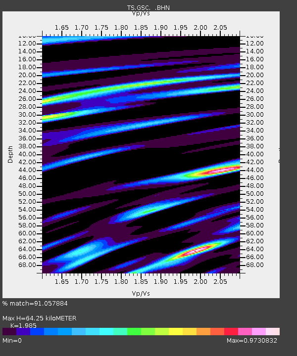
| Estimated Moho Depth: |
64.25 km |
| Estimated Crust Vp/Vs: |
1.99 |
| Assumed Crust Vp: |
6.276 km/s |
| Estimated Crust Vs: |
3.162 km/s |
| Estimated Crust Poisson's Ratio: |
0.33 |
|
| Radial Match: |
91.057884 % |
| Radial Bump: |
400 |
| Transverse Match: |
81.664925 % |
| Transverse Bump: |
400 |
| SOD ConfigId: |
16938 |
| Insert Time: |
2010-02-26 14:15:03.561 +0000 |
| GWidth: |
2.5 |
| Max Bumps: |
400 |
| Tol: |
0.001 |
|

Signal To Noise
| Channel | StoN | STA | LTA |
| TS:GSC: :BHN:19910405T04:28:52.394995Z | 2.8919866 | 1.1050881E-6 | 3.8212073E-7 |
| TS:GSC: :BHE:19910405T04:28:52.394995Z | 2.3929532 | 6.140559E-7 | 2.566101E-7 |
| TS:GSC: :BHZ:19910405T04:28:52.394995Z | 5.0849495 | 1.4792178E-6 | 2.9090117E-7 |
| Arrivals |
| Ps | 11 SECOND |
| PpPs | 29 SECOND |
| PsPs/PpSs | 40 SECOND |


