You are here: Home > Network List > TA - USArray Transportable Network (new EarthScope stations) Stations List
> Station 527A Woodward Ranch, Alpine, TX, USA > Earthquake Result Viewer
527A Woodward Ranch, Alpine, TX, USA - Earthquake Result Viewer
| Earthquake location: |
Off East Coast Of Honshu, Japan |
| Earthquake latitude/longitude: |
37.6/142.2 |
| Earthquake time(UTC): |
2008/07/19 (201) 02:39:28 GMT |
| Earthquake Depth: |
22 km |
| Earthquake Magnitude: |
6.2 MB, 7.0 MS, 7.0 MW, 6.9 MW |
| Earthquake Catalog/Contributor: |
WHDF/NEIC |
|
| Network: |
TA USArray Transportable Network (new EarthScope stations) |
| Station: |
527A Woodward Ranch, Alpine, TX, USA |
| Lat/Lon: |
30.15 N/103.61 W |
| Elevation: |
1419 m |
|
| Distance: |
88.8 deg |
| Az: |
52.226 deg |
| Baz: |
313.511 deg |
| Ray Param: |
0.04231233 |
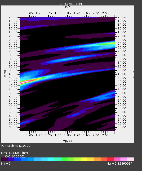
| Estimated Moho Depth: |
44.0 km |
| Estimated Crust Vp/Vs: |
1.62 |
| Assumed Crust Vp: |
6.121 km/s |
| Estimated Crust Vs: |
3.772 km/s |
| Estimated Crust Poisson's Ratio: |
0.19 |
|
| Radial Match: |
94.10727 % |
| Radial Bump: |
338 |
| Transverse Match: |
83.14265 % |
| Transverse Bump: |
400 |
| SOD ConfigId: |
2504 |
| Insert Time: |
2010-03-06 23:24:06.169 +0000 |
| GWidth: |
2.5 |
| Max Bumps: |
400 |
| Tol: |
0.001 |
|
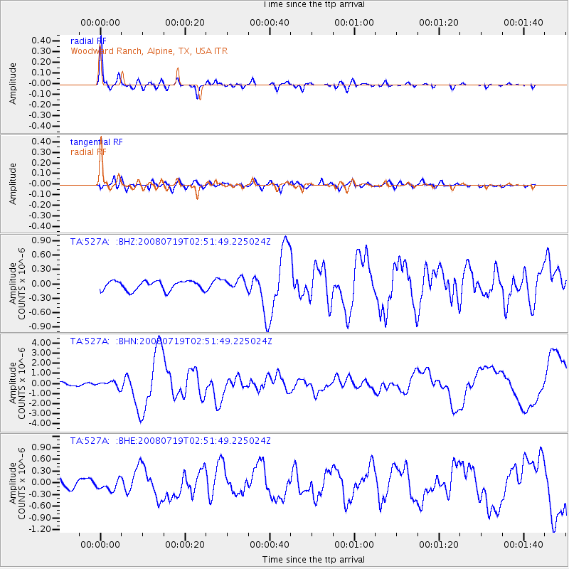
Signal To Noise
| Channel | StoN | STA | LTA |
| TA:527A: :BHN:20080719T02:51:49.225024Z | 1.9492722 | 3.0859536E-7 | 1.5831313E-7 |
| TA:527A: :BHE:20080719T02:51:49.225024Z | 1.3073173 | 1.4009876E-7 | 1.07165086E-7 |
| TA:527A: :BHZ:20080719T02:51:49.225024Z | 1.1643064 | 1.12172145E-7 | 9.634246E-8 |
| Arrivals |
| Ps | 4.6 SECOND |
| PpPs | 18 SECOND |
| PsPs/PpSs | 23 SECOND |


