You are here: Home > Network List > TA - USArray Transportable Network (new EarthScope stations) Stations List
> Station 527A Woodward Ranch, Alpine, TX, USA > Earthquake Result Viewer
527A Woodward Ranch, Alpine, TX, USA - Earthquake Result Viewer
| Earthquake location: |
Peru-Brazil Border Region |
| Earthquake latitude/longitude: |
-7.6/-74.4 |
| Earthquake time(UTC): |
2008/08/26 (239) 21:00:36 GMT |
| Earthquake Depth: |
154 km |
| Earthquake Magnitude: |
6.0 MB, 6.4 MW, 6.4 MW |
| Earthquake Catalog/Contributor: |
WHDF/NEIC |
|
| Network: |
TA USArray Transportable Network (new EarthScope stations) |
| Station: |
527A Woodward Ranch, Alpine, TX, USA |
| Lat/Lon: |
30.15 N/103.61 W |
| Elevation: |
1419 m |
|
| Distance: |
46.9 deg |
| Az: |
324.593 deg |
| Baz: |
138.471 deg |
| Ray Param: |
0.06978124 |
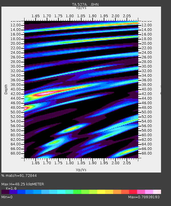
| Estimated Moho Depth: |
48.25 km |
| Estimated Crust Vp/Vs: |
1.60 |
| Assumed Crust Vp: |
6.121 km/s |
| Estimated Crust Vs: |
3.825 km/s |
| Estimated Crust Poisson's Ratio: |
0.18 |
|
| Radial Match: |
91.72844 % |
| Radial Bump: |
339 |
| Transverse Match: |
72.00971 % |
| Transverse Bump: |
400 |
| SOD ConfigId: |
2504 |
| Insert Time: |
2010-03-06 23:24:15.691 +0000 |
| GWidth: |
2.5 |
| Max Bumps: |
400 |
| Tol: |
0.001 |
|
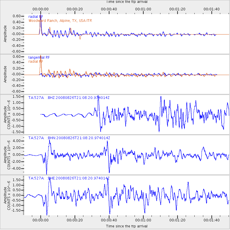
Signal To Noise
| Channel | StoN | STA | LTA |
| TA:527A: :BHN:20080826T21:08:20.974014Z | 20.206985 | 1.8201301E-6 | 9.007431E-8 |
| TA:527A: :BHE:20080826T21:08:20.974014Z | 10.497901 | 7.845509E-7 | 7.4734075E-8 |
| TA:527A: :BHZ:20080826T21:08:20.974014Z | 8.026701 | 5.783782E-7 | 7.205678E-8 |
| Arrivals |
| Ps | 5.0 SECOND |
| PpPs | 19 SECOND |
| PsPs/PpSs | 24 SECOND |


