You are here: Home > Network List > TA - USArray Transportable Network (new EarthScope stations) Stations List
> Station B18K Kokolik River, AK, USA > Earthquake Result Viewer
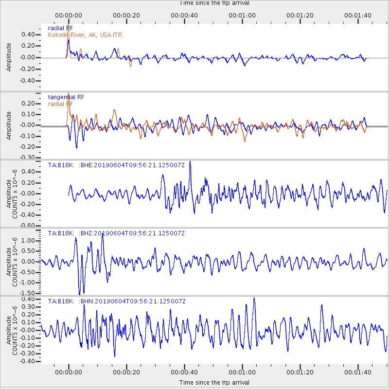
B18K Kokolik River, AK, USA - Earthquake Result Viewer
*The percent match for this event was below the threshold and hence no stack was calculated.
| Earthquake location: |
Taiwan Region |
| Earthquake latitude/longitude: |
22.9/121.7 |
| Earthquake time(UTC): |
2019/06/04 (155) 09:46:18 GMT |
| Earthquake Depth: |
10 km |
| Earthquake Magnitude: |
5.6 Mww |
| Earthquake Catalog/Contributor: |
NEIC PDE/us |
|
| Network: |
TA USArray Transportable Network (new EarthScope stations) |
| Station: |
B18K Kokolik River, AK, USA |
| Lat/Lon: |
69.36 N/161.80 W |
| Elevation: |
222 m |
|
| Distance: |
64.0 deg |
| Az: |
22.546 deg |
| Baz: |
265.928 deg |
| Ray Param: |
$rayparam |
*The percent match for this event was below the threshold and hence was not used in the summary stack. |
|
| Radial Match: |
68.94218 % |
| Radial Bump: |
400 |
| Transverse Match: |
70.125656 % |
| Transverse Bump: |
400 |
| SOD ConfigId: |
18369291 |
| Insert Time: |
2019-06-18 09:51:03.319 +0000 |
| GWidth: |
2.5 |
| Max Bumps: |
400 |
| Tol: |
0.001 |
|
Signal To Noise
| Channel | StoN | STA | LTA |
| TA:B18K: :BHZ:20190604T09:56:21.125007Z | 4.252366 | 6.42554E-7 | 1.5110504E-7 |
| TA:B18K: :BHN:20190604T09:56:21.125007Z | 1.3483639 | 9.048981E-8 | 6.7110825E-8 |
| TA:B18K: :BHE:20190604T09:56:21.125007Z | 2.38604 | 1.6503628E-7 | 6.916744E-8 |
| Arrivals |
| Ps | |
| PpPs | |
| PsPs/PpSs | |


