You are here: Home > Network List > TA - USArray Transportable Network (new EarthScope stations) Stations List
> Station E20K Nigu River, AK, USA > Earthquake Result Viewer
E20K Nigu River, AK, USA - Earthquake Result Viewer

| Earthquake location: |
Taiwan Region |
| Earthquake latitude/longitude: |
22.9/121.7 |
| Earthquake time(UTC): |
2019/06/04 (155) 09:46:18 GMT |
| Earthquake Depth: |
10 km |
| Earthquake Magnitude: |
5.6 Mww |
| Earthquake Catalog/Contributor: |
NEIC PDE/us |
|
| Network: |
TA USArray Transportable Network (new EarthScope stations) |
| Station: |
E20K Nigu River, AK, USA |
| Lat/Lon: |
68.26 N/156.19 W |
| Elevation: |
866 m |
|
| Distance: |
66.1 deg |
| Az: |
23.817 deg |
| Baz: |
271.694 deg |
| Ray Param: |
0.05786276 |
| Estimated Moho Depth: |
36.0 km |
| Estimated Crust Vp/Vs: |
1.98 |
| Assumed Crust Vp: |
6.221 km/s |
| Estimated Crust Vs: |
3.15 km/s |
| Estimated Crust Poisson's Ratio: |
0.33 |
|
| Radial Match: |
84.925835 % |
| Radial Bump: |
400 |
| Transverse Match: |
72.657814 % |
| Transverse Bump: |
400 |
| SOD ConfigId: |
18369291 |
| Insert Time: |
2019-06-18 09:51:16.014 +0000 |
| GWidth: |
2.5 |
| Max Bumps: |
400 |
| Tol: |
0.001 |
|
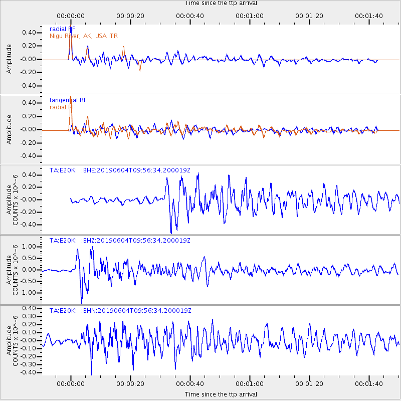
Signal To Noise
| Channel | StoN | STA | LTA |
| TA:E20K: :BHZ:20190604T09:56:34.200019Z | 8.882918 | 5.221949E-7 | 5.8786416E-8 |
| TA:E20K: :BHN:20190604T09:56:34.200019Z | 1.0237831 | 4.2040327E-8 | 4.1063707E-8 |
| TA:E20K: :BHE:20190604T09:56:34.200019Z | 6.7886896 | 1.9768048E-7 | 2.9119091E-8 |
| Arrivals |
| Ps | 5.8 SECOND |
| PpPs | 17 SECOND |
| PsPs/PpSs | 22 SECOND |


