You are here: Home > Network List > TA - USArray Transportable Network (new EarthScope stations) Stations List
> Station 527A Woodward Ranch, Alpine, TX, USA > Earthquake Result Viewer
527A Woodward Ranch, Alpine, TX, USA - Earthquake Result Viewer
| Earthquake location: |
Central East Pacific Rise |
| Earthquake latitude/longitude: |
-9.0/-108.2 |
| Earthquake time(UTC): |
2008/10/30 (304) 15:15:41 GMT |
| Earthquake Depth: |
10 km |
| Earthquake Magnitude: |
5.5 MB, 5.8 MS, 6.0 MW, 6.0 MW |
| Earthquake Catalog/Contributor: |
WHDF/NEIC |
|
| Network: |
TA USArray Transportable Network (new EarthScope stations) |
| Station: |
527A Woodward Ranch, Alpine, TX, USA |
| Lat/Lon: |
30.15 N/103.61 W |
| Elevation: |
1419 m |
|
| Distance: |
39.2 deg |
| Az: |
6.358 deg |
| Baz: |
187.255 deg |
| Ray Param: |
0.0751254 |
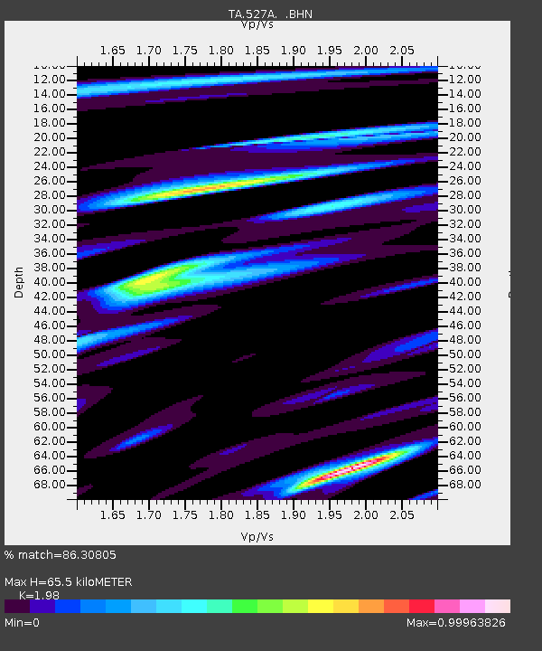
| Estimated Moho Depth: |
65.5 km |
| Estimated Crust Vp/Vs: |
1.98 |
| Assumed Crust Vp: |
6.121 km/s |
| Estimated Crust Vs: |
3.091 km/s |
| Estimated Crust Poisson's Ratio: |
0.33 |
|
| Radial Match: |
86.30805 % |
| Radial Bump: |
342 |
| Transverse Match: |
71.77211 % |
| Transverse Bump: |
383 |
| SOD ConfigId: |
2560 |
| Insert Time: |
2010-03-06 23:24:32.897 +0000 |
| GWidth: |
2.5 |
| Max Bumps: |
400 |
| Tol: |
0.001 |
|
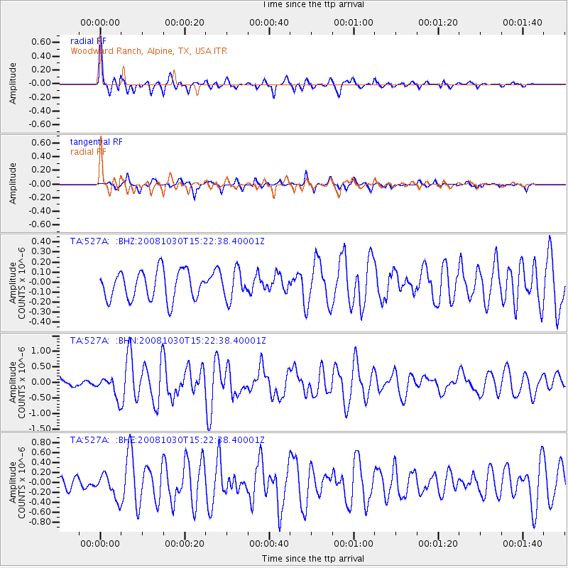
Signal To Noise
| Channel | StoN | STA | LTA |
| TA:527A: :BHN:20081030T15:22:38.40001Z | 2.4961681 | 3.3966447E-7 | 1.3607436E-7 |
| TA:527A: :BHE:20081030T15:22:38.40001Z | 2.1732798 | 2.4958217E-7 | 1.1484126E-7 |
| TA:527A: :BHZ:20081030T15:22:38.40001Z | 1.0011246 | 1.4360303E-7 | 1.4344171E-7 |
| Arrivals |
| Ps | 11 SECOND |
| PpPs | 30 SECOND |
| PsPs/PpSs | 41 SECOND |


