You are here: Home > Network List > TA - USArray Transportable Network (new EarthScope stations) Stations List
> Station G18K Tagagawik, AK, USA > Earthquake Result Viewer
G18K Tagagawik, AK, USA - Earthquake Result Viewer
| Earthquake location: |
Taiwan Region |
| Earthquake latitude/longitude: |
22.9/121.7 |
| Earthquake time(UTC): |
2019/06/04 (155) 09:46:18 GMT |
| Earthquake Depth: |
10 km |
| Earthquake Magnitude: |
5.6 Mww |
| Earthquake Catalog/Contributor: |
NEIC PDE/us |
|
| Network: |
TA USArray Transportable Network (new EarthScope stations) |
| Station: |
G18K Tagagawik, AK, USA |
| Lat/Lon: |
65.89 N/158.65 W |
| Elevation: |
484 m |
|
| Distance: |
65.1 deg |
| Az: |
26.443 deg |
| Baz: |
270.51 deg |
| Ray Param: |
0.058466777 |
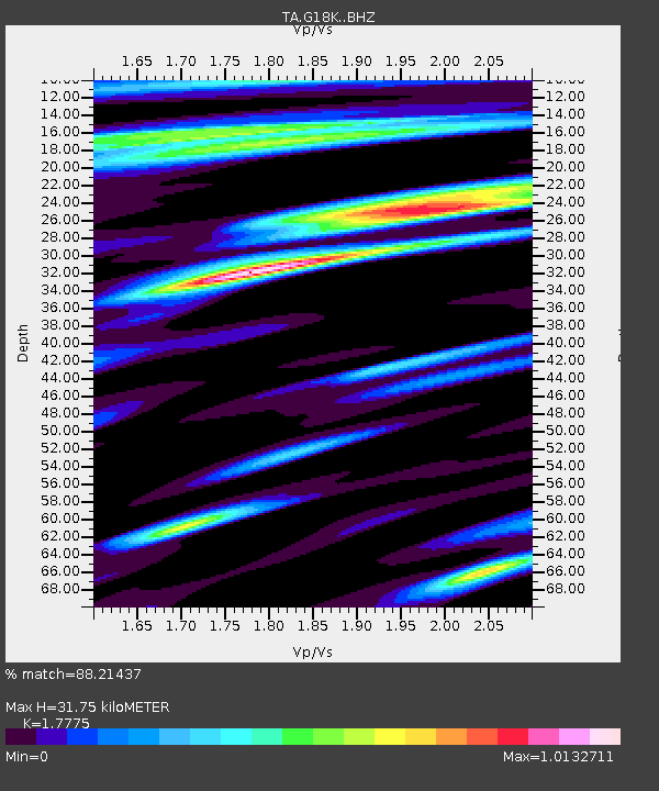
| Estimated Moho Depth: |
31.75 km |
| Estimated Crust Vp/Vs: |
1.78 |
| Assumed Crust Vp: |
6.1 km/s |
| Estimated Crust Vs: |
3.432 km/s |
| Estimated Crust Poisson's Ratio: |
0.27 |
|
| Radial Match: |
88.21437 % |
| Radial Bump: |
400 |
| Transverse Match: |
77.59079 % |
| Transverse Bump: |
400 |
| SOD ConfigId: |
18369291 |
| Insert Time: |
2019-06-18 09:51:31.262 +0000 |
| GWidth: |
2.5 |
| Max Bumps: |
400 |
| Tol: |
0.001 |
|

Signal To Noise
| Channel | StoN | STA | LTA |
| TA:G18K: :BHZ:20190604T09:56:28.27497Z | 14.586155 | 4.837319E-7 | 3.3163772E-8 |
| TA:G18K: :BHN:20190604T09:56:28.27497Z | 1.6622889 | 6.137273E-8 | 3.6920618E-8 |
| TA:G18K: :BHE:20190604T09:56:28.27497Z | 6.773365 | 1.5886262E-7 | 2.3454017E-8 |
| Arrivals |
| Ps | 4.2 SECOND |
| PpPs | 14 SECOND |
| PsPs/PpSs | 18 SECOND |


