You are here: Home > Network List > GS - US Geological Survey Networks Stations List
> Station KS21 NEIC Portable/Temp deployment > Earthquake Result Viewer
KS21 NEIC Portable/Temp deployment - Earthquake Result Viewer
| Earthquake location: |
North Of Ascension Island |
| Earthquake latitude/longitude: |
-1.5/-15.6 |
| Earthquake time(UTC): |
2016/10/27 (301) 01:03:12 GMT |
| Earthquake Depth: |
10 km |
| Earthquake Magnitude: |
5.6 MWW, 5.5 MWB |
| Earthquake Catalog/Contributor: |
NEIC PDE/NEIC COMCAT |
|
| Network: |
GS US Geological Survey Networks |
| Station: |
KS21 NEIC Portable/Temp deployment |
| Lat/Lon: |
37.29 N/97.66 W |
| Elevation: |
414 m |
|
| Distance: |
84.6 deg |
| Az: |
307.488 deg |
| Baz: |
95.996 deg |
| Ray Param: |
0.045371663 |
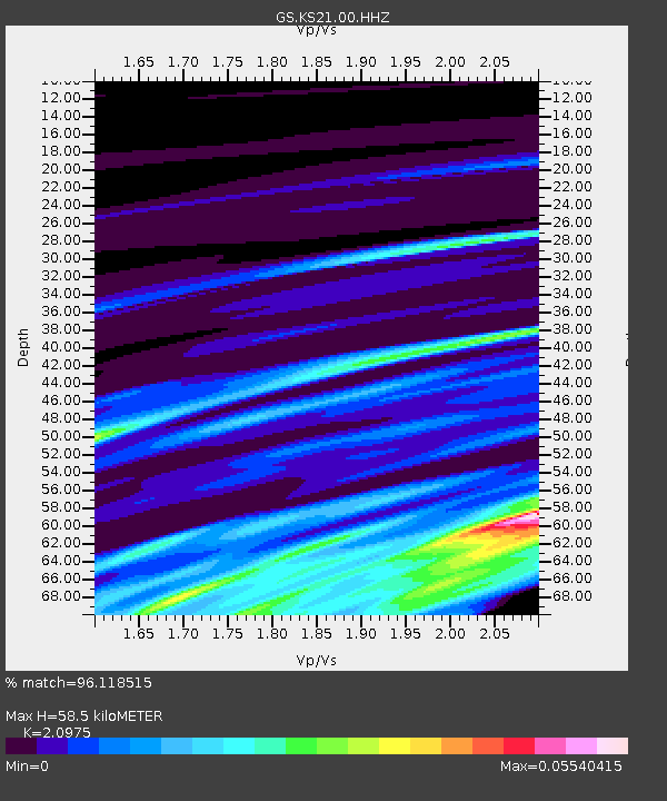
| Estimated Moho Depth: |
58.5 km |
| Estimated Crust Vp/Vs: |
2.10 |
| Assumed Crust Vp: |
6.483 km/s |
| Estimated Crust Vs: |
3.091 km/s |
| Estimated Crust Poisson's Ratio: |
0.35 |
|
| Radial Match: |
96.118515 % |
| Radial Bump: |
199 |
| Transverse Match: |
99.774796 % |
| Transverse Bump: |
31 |
| SOD ConfigId: |
1858631 |
| Insert Time: |
2016-11-29 05:30:11.102 +0000 |
| GWidth: |
2.5 |
| Max Bumps: |
400 |
| Tol: |
0.001 |
|

Signal To Noise
| Channel | StoN | STA | LTA |
| GS:KS21:00:HHZ:20161027T01:15:14.249026Z | 1.9830348 | 4.704624E-6 | 2.3724363E-6 |
| GS:KS21:00:HH1:20161027T01:15:14.249026Z | 1.9859205 | 1.979341E-6 | 9.966869E-7 |
| GS:KS21:00:HH2:20161027T01:15:14.249026Z | 1.9954844 | 7.940136E-7 | 3.979052E-7 |
| Arrivals |
| Ps | 10 SECOND |
| PpPs | 27 SECOND |
| PsPs/PpSs | 37 SECOND |


