You are here: Home > Network List > TA - USArray Transportable Network (new EarthScope stations) Stations List
> Station 527A Woodward Ranch, Alpine, TX, USA > Earthquake Result Viewer
527A Woodward Ranch, Alpine, TX, USA - Earthquake Result Viewer
| Earthquake location: |
Samoa Islands Region |
| Earthquake latitude/longitude: |
-16.2/-173.0 |
| Earthquake time(UTC): |
2009/09/29 (272) 18:21:42 GMT |
| Earthquake Depth: |
10 km |
| Earthquake Magnitude: |
5.8 MB |
| Earthquake Catalog/Contributor: |
WHDF/NEIC |
|
| Network: |
TA USArray Transportable Network (new EarthScope stations) |
| Station: |
527A Woodward Ranch, Alpine, TX, USA |
| Lat/Lon: |
30.15 N/103.61 W |
| Elevation: |
1419 m |
|
| Distance: |
81.1 deg |
| Az: |
55.136 deg |
| Baz: |
245.516 deg |
| Ray Param: |
0.047823917 |
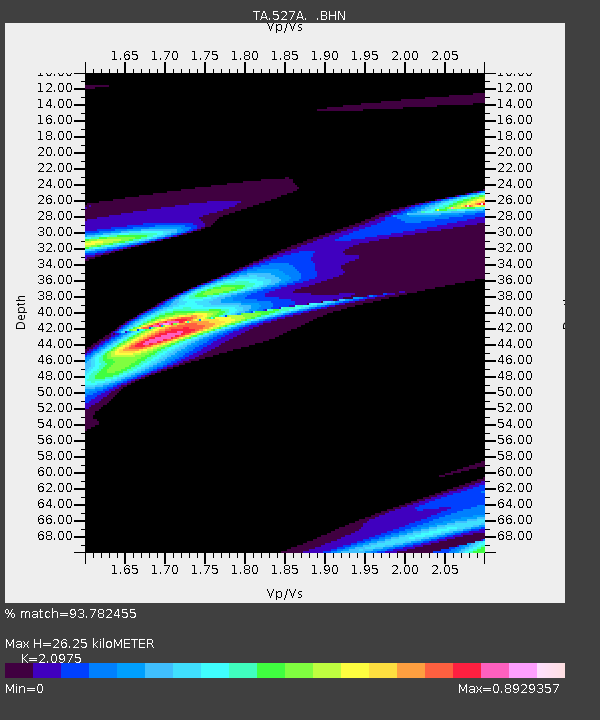
| Estimated Moho Depth: |
26.25 km |
| Estimated Crust Vp/Vs: |
2.10 |
| Assumed Crust Vp: |
6.121 km/s |
| Estimated Crust Vs: |
2.918 km/s |
| Estimated Crust Poisson's Ratio: |
0.35 |
|
| Radial Match: |
93.782455 % |
| Radial Bump: |
393 |
| Transverse Match: |
67.33865 % |
| Transverse Bump: |
400 |
| SOD ConfigId: |
2622 |
| Insert Time: |
2010-03-06 23:24:57.921 +0000 |
| GWidth: |
2.5 |
| Max Bumps: |
400 |
| Tol: |
0.001 |
|

Signal To Noise
| Channel | StoN | STA | LTA |
| TA:527A: :BHN:20090929T18:33:26.374001Z | 2.2383053 | 1.0080874E-4 | 4.5037978E-5 |
| TA:527A: :BHE:20090929T18:33:26.374001Z | 2.6279364 | 3.9241982E-5 | 1.4932623E-5 |
| TA:527A: :BHZ:20090929T18:33:26.374001Z | 1.8775337 | 4.1708412E-5 | 2.2214468E-5 |
| Arrivals |
| Ps | 4.8 SECOND |
| PpPs | 13 SECOND |
| PsPs/PpSs | 18 SECOND |


