You are here: Home > Network List > TA - USArray Transportable Network (new EarthScope stations) Stations List
> Station L17K Donlin, AK, USA > Earthquake Result Viewer
L17K Donlin, AK, USA - Earthquake Result Viewer
| Earthquake location: |
Taiwan Region |
| Earthquake latitude/longitude: |
22.9/121.7 |
| Earthquake time(UTC): |
2019/06/04 (155) 09:46:18 GMT |
| Earthquake Depth: |
10 km |
| Earthquake Magnitude: |
5.6 Mww |
| Earthquake Catalog/Contributor: |
NEIC PDE/us |
|
| Network: |
TA USArray Transportable Network (new EarthScope stations) |
| Station: |
L17K Donlin, AK, USA |
| Lat/Lon: |
62.13 N/158.30 W |
| Elevation: |
338 m |
|
| Distance: |
65.4 deg |
| Az: |
30.595 deg |
| Baz: |
272.568 deg |
| Ray Param: |
0.058296878 |
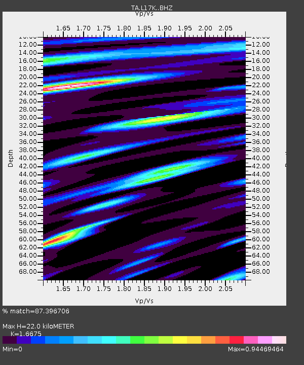
| Estimated Moho Depth: |
22.0 km |
| Estimated Crust Vp/Vs: |
1.67 |
| Assumed Crust Vp: |
6.276 km/s |
| Estimated Crust Vs: |
3.764 km/s |
| Estimated Crust Poisson's Ratio: |
0.22 |
|
| Radial Match: |
87.396706 % |
| Radial Bump: |
400 |
| Transverse Match: |
76.6317 % |
| Transverse Bump: |
400 |
| SOD ConfigId: |
18369291 |
| Insert Time: |
2019-06-18 09:52:06.333 +0000 |
| GWidth: |
2.5 |
| Max Bumps: |
400 |
| Tol: |
0.001 |
|

Signal To Noise
| Channel | StoN | STA | LTA |
| TA:L17K: :BHZ:20190604T09:56:29.950019Z | 10.443042 | 6.417735E-7 | 6.145465E-8 |
| TA:L17K: :BHN:20190604T09:56:29.950019Z | 1.7488741 | 7.215466E-8 | 4.125778E-8 |
| TA:L17K: :BHE:20190604T09:56:29.950019Z | 5.5734754 | 2.8927502E-7 | 5.190209E-8 |
| Arrivals |
| Ps | 2.4 SECOND |
| PpPs | 9.0 SECOND |
| PsPs/PpSs | 11 SECOND |


