You are here: Home > Network List > TA - USArray Transportable Network (new EarthScope stations) Stations List
> Station N15K Kwethluk River, AK, USA > Earthquake Result Viewer
N15K Kwethluk River, AK, USA - Earthquake Result Viewer
| Earthquake location: |
Taiwan Region |
| Earthquake latitude/longitude: |
22.9/121.7 |
| Earthquake time(UTC): |
2019/06/04 (155) 09:46:18 GMT |
| Earthquake Depth: |
10 km |
| Earthquake Magnitude: |
5.6 Mww |
| Earthquake Catalog/Contributor: |
NEIC PDE/us |
|
| Network: |
TA USArray Transportable Network (new EarthScope stations) |
| Station: |
N15K Kwethluk River, AK, USA |
| Lat/Lon: |
60.17 N/160.09 W |
| Elevation: |
449 m |
|
| Distance: |
64.6 deg |
| Az: |
32.807 deg |
| Baz: |
271.933 deg |
| Ray Param: |
0.058813475 |
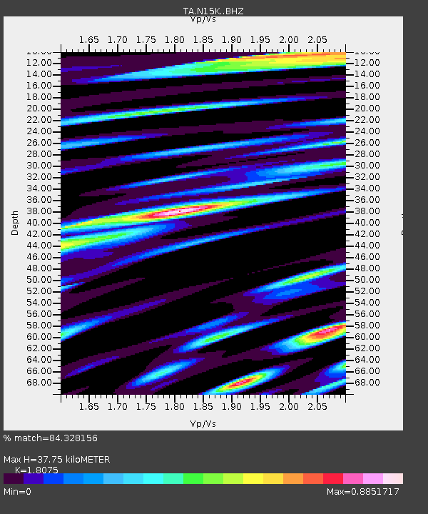
| Estimated Moho Depth: |
37.75 km |
| Estimated Crust Vp/Vs: |
1.81 |
| Assumed Crust Vp: |
6.182 km/s |
| Estimated Crust Vs: |
3.42 km/s |
| Estimated Crust Poisson's Ratio: |
0.28 |
|
| Radial Match: |
84.328156 % |
| Radial Bump: |
400 |
| Transverse Match: |
64.3821 % |
| Transverse Bump: |
400 |
| SOD ConfigId: |
18369291 |
| Insert Time: |
2019-06-18 09:52:22.589 +0000 |
| GWidth: |
2.5 |
| Max Bumps: |
400 |
| Tol: |
0.001 |
|

Signal To Noise
| Channel | StoN | STA | LTA |
| TA:N15K: :BHZ:20190604T09:56:24.799995Z | 9.387134 | 6.178495E-7 | 6.581876E-8 |
| TA:N15K: :BHN:20190604T09:56:24.799995Z | 2.282415 | 1.3349101E-7 | 5.8486737E-8 |
| TA:N15K: :BHE:20190604T09:56:24.799995Z | 2.5766337 | 2.2645759E-7 | 8.7888935E-8 |
| Arrivals |
| Ps | 5.1 SECOND |
| PpPs | 16 SECOND |
| PsPs/PpSs | 22 SECOND |


