You are here: Home > Network List > TA - USArray Transportable Network (new EarthScope stations) Stations List
> Station O18K Koktuh Hills, AK, USA > Earthquake Result Viewer
O18K Koktuh Hills, AK, USA - Earthquake Result Viewer
| Earthquake location: |
Taiwan Region |
| Earthquake latitude/longitude: |
22.9/121.7 |
| Earthquake time(UTC): |
2019/06/04 (155) 09:46:18 GMT |
| Earthquake Depth: |
10 km |
| Earthquake Magnitude: |
5.6 Mww |
| Earthquake Catalog/Contributor: |
NEIC PDE/us |
|
| Network: |
TA USArray Transportable Network (new EarthScope stations) |
| Station: |
O18K Koktuh Hills, AK, USA |
| Lat/Lon: |
59.85 N/155.21 W |
| Elevation: |
544 m |
|
| Distance: |
67.1 deg |
| Az: |
32.96 deg |
| Baz: |
276.22 deg |
| Ray Param: |
0.05719199 |
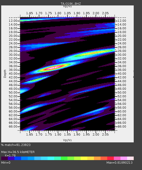
| Estimated Moho Depth: |
36.5 km |
| Estimated Crust Vp/Vs: |
1.78 |
| Assumed Crust Vp: |
6.438 km/s |
| Estimated Crust Vs: |
3.617 km/s |
| Estimated Crust Poisson's Ratio: |
0.27 |
|
| Radial Match: |
91.23923 % |
| Radial Bump: |
399 |
| Transverse Match: |
83.740616 % |
| Transverse Bump: |
400 |
| SOD ConfigId: |
18369291 |
| Insert Time: |
2019-06-18 09:52:30.878 +0000 |
| GWidth: |
2.5 |
| Max Bumps: |
400 |
| Tol: |
0.001 |
|
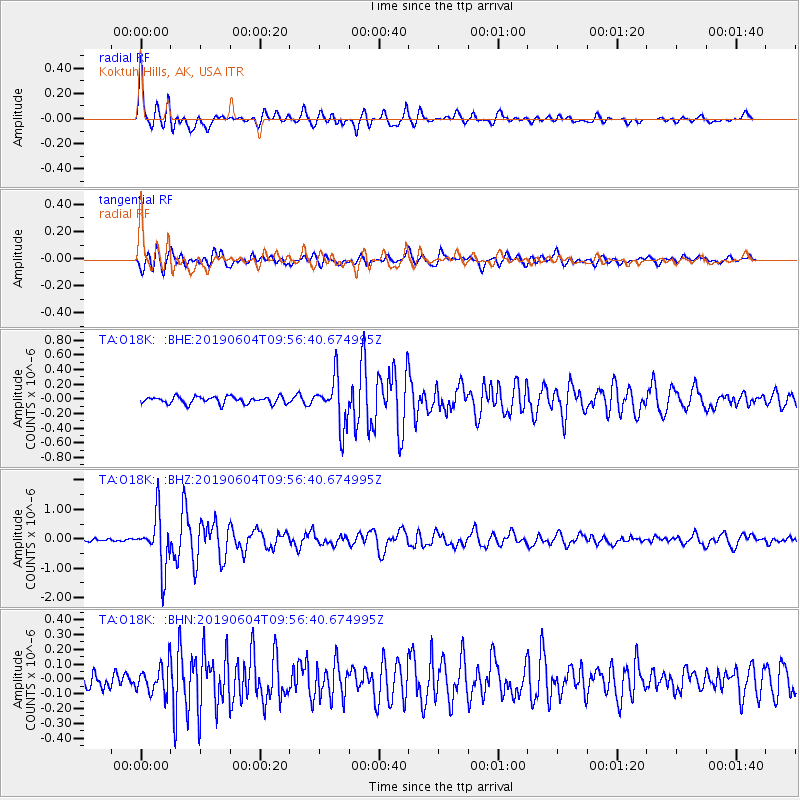
Signal To Noise
| Channel | StoN | STA | LTA |
| TA:O18K: :BHZ:20190604T09:56:40.674995Z | 20.297518 | 9.060893E-7 | 4.46404E-8 |
| TA:O18K: :BHN:20190604T09:56:40.674995Z | 2.0479631 | 9.731906E-8 | 4.7519926E-8 |
| TA:O18K: :BHE:20190604T09:56:40.674995Z | 6.887352 | 3.278953E-7 | 4.7608328E-8 |
| Arrivals |
| Ps | 4.6 SECOND |
| PpPs | 15 SECOND |
| PsPs/PpSs | 20 SECOND |


