You are here: Home > Network List > TA - USArray Transportable Network (new EarthScope stations) Stations List
> Station P17K Kvichak River, AK, USA > Earthquake Result Viewer
P17K Kvichak River, AK, USA - Earthquake Result Viewer
| Earthquake location: |
Taiwan Region |
| Earthquake latitude/longitude: |
22.9/121.7 |
| Earthquake time(UTC): |
2019/06/04 (155) 09:46:18 GMT |
| Earthquake Depth: |
10 km |
| Earthquake Magnitude: |
5.6 Mww |
| Earthquake Catalog/Contributor: |
NEIC PDE/us |
|
| Network: |
TA USArray Transportable Network (new EarthScope stations) |
| Station: |
P17K Kvichak River, AK, USA |
| Lat/Lon: |
59.20 N/156.44 W |
| Elevation: |
91 m |
|
| Distance: |
66.5 deg |
| Az: |
33.745 deg |
| Baz: |
275.469 deg |
| Ray Param: |
0.05756276 |
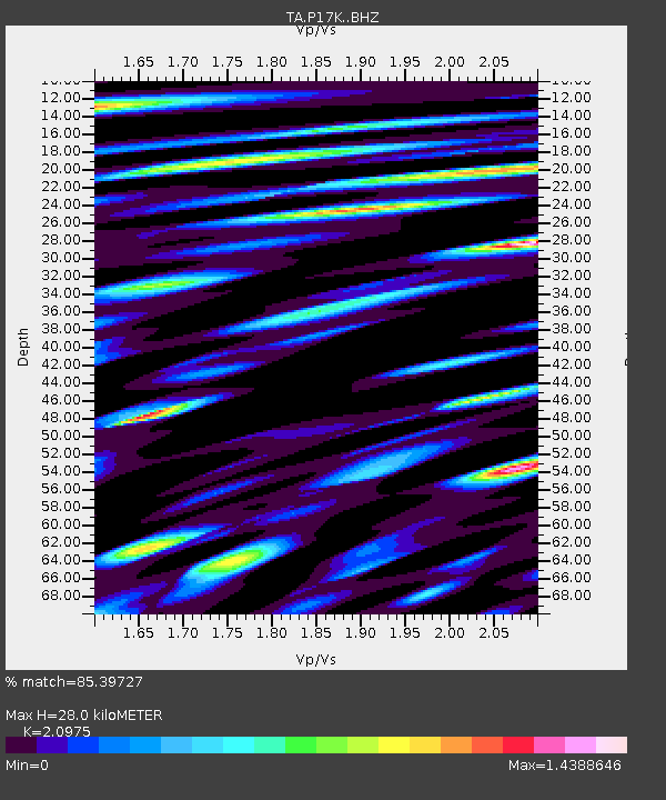
| Estimated Moho Depth: |
28.0 km |
| Estimated Crust Vp/Vs: |
2.10 |
| Assumed Crust Vp: |
6.276 km/s |
| Estimated Crust Vs: |
2.992 km/s |
| Estimated Crust Poisson's Ratio: |
0.35 |
|
| Radial Match: |
85.39727 % |
| Radial Bump: |
400 |
| Transverse Match: |
82.15451 % |
| Transverse Bump: |
400 |
| SOD ConfigId: |
18369291 |
| Insert Time: |
2019-06-18 09:52:35.947 +0000 |
| GWidth: |
2.5 |
| Max Bumps: |
400 |
| Tol: |
0.001 |
|
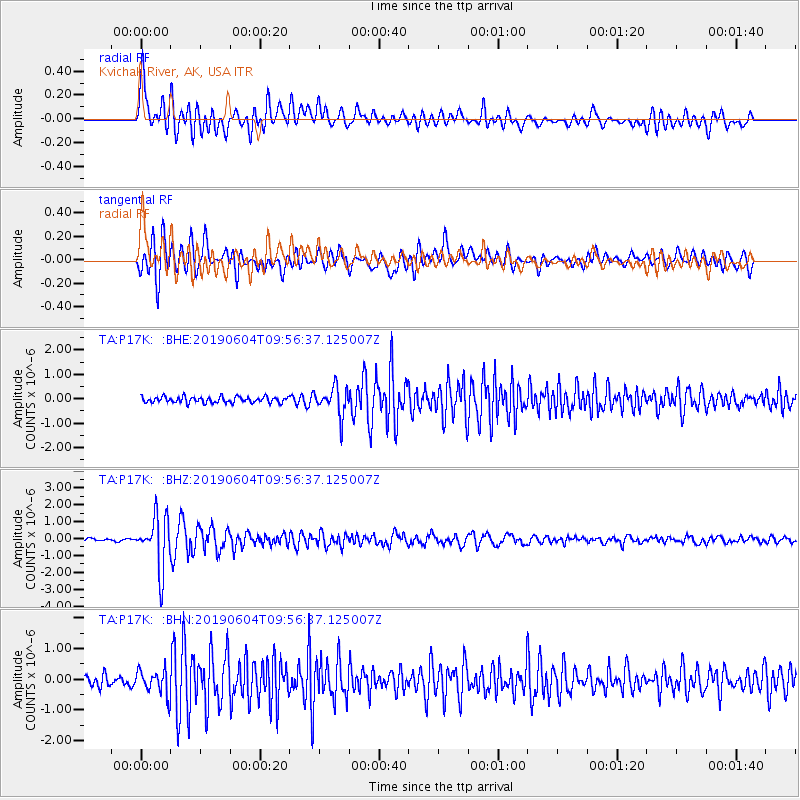
Signal To Noise
| Channel | StoN | STA | LTA |
| TA:P17K: :BHZ:20190604T09:56:37.125007Z | 17.881083 | 1.5547622E-6 | 8.695011E-8 |
| TA:P17K: :BHN:20190604T09:56:37.125007Z | 2.7244546 | 4.030934E-7 | 1.479538E-7 |
| TA:P17K: :BHE:20190604T09:56:37.125007Z | 4.655485 | 5.798838E-7 | 1.2455928E-7 |
| Arrivals |
| Ps | 5.1 SECOND |
| PpPs | 13 SECOND |
| PsPs/PpSs | 18 SECOND |


