You are here: Home > Network List > TA - USArray Transportable Network (new EarthScope stations) Stations List
> Station 527A Woodward Ranch, Alpine, TX, USA > Earthquake Result Viewer
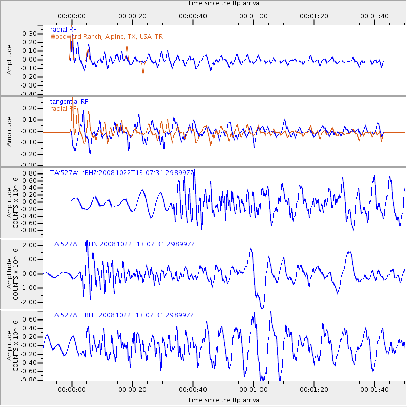
527A Woodward Ranch, Alpine, TX, USA - Earthquake Result Viewer
*The percent match for this event was below the threshold and hence no stack was calculated.
| Earthquake location: |
Tonga Islands |
| Earthquake latitude/longitude: |
-18.4/-175.4 |
| Earthquake time(UTC): |
2008/10/22 (296) 12:55:57 GMT |
| Earthquake Depth: |
233 km |
| Earthquake Magnitude: |
5.9 MB, 6.4 MW, 6.3 MW |
| Earthquake Catalog/Contributor: |
WHDF/NEIC |
|
| Network: |
TA USArray Transportable Network (new EarthScope stations) |
| Station: |
527A Woodward Ranch, Alpine, TX, USA |
| Lat/Lon: |
30.15 N/103.61 W |
| Elevation: |
1419 m |
|
| Distance: |
84.2 deg |
| Az: |
55.771 deg |
| Baz: |
244.99 deg |
| Ray Param: |
$rayparam |
*The percent match for this event was below the threshold and hence was not used in the summary stack. |
|
| Radial Match: |
55.6439 % |
| Radial Bump: |
400 |
| Transverse Match: |
76.62641 % |
| Transverse Bump: |
400 |
| SOD ConfigId: |
2556 |
| Insert Time: |
2010-03-06 23:25:44.466 +0000 |
| GWidth: |
2.5 |
| Max Bumps: |
400 |
| Tol: |
0.001 |
|
Signal To Noise
| Channel | StoN | STA | LTA |
| TA:527A: :BHN:20081022T13:07:31.298997Z | 2.870941 | 4.881918E-7 | 1.7004592E-7 |
| TA:527A: :BHE:20081022T13:07:31.298997Z | 0.79398406 | 1.6060268E-7 | 2.0227445E-7 |
| TA:527A: :BHZ:20081022T13:07:31.298997Z | 1.6475711 | 2.1920692E-7 | 1.3304854E-7 |
| Arrivals |
| Ps | |
| PpPs | |
| PsPs/PpSs | |


