You are here: Home > Network List > GS - US Geological Survey Networks Stations List
> Station OK051 E0350 and S34600 Roads, Ralston, OK > Earthquake Result Viewer
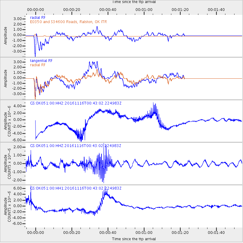
OK051 E0350 and S34600 Roads, Ralston, OK - Earthquake Result Viewer
*The percent match for this event was below the threshold and hence no stack was calculated.
| Earthquake location: |
Tonga Islands Region |
| Earthquake latitude/longitude: |
-20.2/-173.0 |
| Earthquake time(UTC): |
2016/11/16 (321) 00:30:28 GMT |
| Earthquake Depth: |
10 km |
| Earthquake Magnitude: |
5.9 MB, 5.6 MWB |
| Earthquake Catalog/Contributor: |
NEIC PDE/NEIC COMCAT |
|
| Network: |
GS US Geological Survey Networks |
| Station: |
OK051 E0350 and S34600 Roads, Ralston, OK |
| Lat/Lon: |
36.51 N/96.84 W |
| Elevation: |
263 m |
|
| Distance: |
91.2 deg |
| Az: |
51.48 deg |
| Baz: |
245.795 deg |
| Ray Param: |
$rayparam |
*The percent match for this event was below the threshold and hence was not used in the summary stack. |
|
| Radial Match: |
69.95912 % |
| Radial Bump: |
400 |
| Transverse Match: |
80.08053 % |
| Transverse Bump: |
327 |
| SOD ConfigId: |
1858631 |
| Insert Time: |
2016-11-30 00:32:12.316 +0000 |
| GWidth: |
2.5 |
| Max Bumps: |
400 |
| Tol: |
0.001 |
|
Signal To Noise
| Channel | StoN | STA | LTA |
| GS:OK051:00:HHZ:20161116T00:43:02.224983Z | 1.6434118 | 3.5939024E-7 | 2.1868546E-7 |
| GS:OK051:00:HH1:20161116T00:43:02.224983Z | 2.5692015 | 1.9853246E-6 | 7.727399E-7 |
| GS:OK051:00:HH2:20161116T00:43:02.224983Z | 2.9797475 | 3.9628408E-6 | 1.329925E-6 |
| Arrivals |
| Ps | |
| PpPs | |
| PsPs/PpSs | |


