You are here: Home > Network List > TA - USArray Transportable Network (new EarthScope stations) Stations List
> Station 527A Woodward Ranch, Alpine, TX, USA > Earthquake Result Viewer
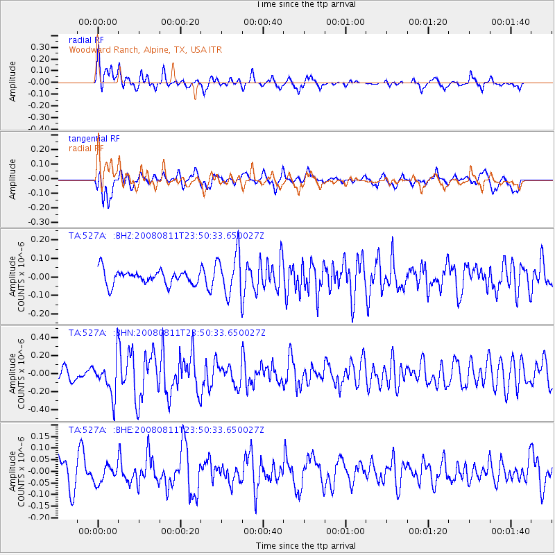
527A Woodward Ranch, Alpine, TX, USA - Earthquake Result Viewer
*The percent match for this event was below the threshold and hence no stack was calculated.
| Earthquake location: |
Central Mid-Atlantic Ridge |
| Earthquake latitude/longitude: |
-1.0/-21.8 |
| Earthquake time(UTC): |
2008/08/11 (224) 23:38:38 GMT |
| Earthquake Depth: |
13 km |
| Earthquake Magnitude: |
6.0 MW, 5.2 MS, 5.4 MB, 6.0 MW |
| Earthquake Catalog/Contributor: |
WHDF/NEIC |
|
| Network: |
TA USArray Transportable Network (new EarthScope stations) |
| Station: |
527A Woodward Ranch, Alpine, TX, USA |
| Lat/Lon: |
30.15 N/103.61 W |
| Elevation: |
1419 m |
|
| Distance: |
83.4 deg |
| Az: |
300.342 deg |
| Baz: |
95.015 deg |
| Ray Param: |
$rayparam |
*The percent match for this event was below the threshold and hence was not used in the summary stack. |
|
| Radial Match: |
61.907223 % |
| Radial Bump: |
400 |
| Transverse Match: |
59.980865 % |
| Transverse Bump: |
400 |
| SOD ConfigId: |
2504 |
| Insert Time: |
2010-03-06 23:26:04.966 +0000 |
| GWidth: |
2.5 |
| Max Bumps: |
400 |
| Tol: |
0.001 |
|
Signal To Noise
| Channel | StoN | STA | LTA |
| TA:527A: :BHN:20080811T23:50:33.650027Z | 2.6210787 | 2.1593225E-7 | 8.238297E-8 |
| TA:527A: :BHE:20080811T23:50:33.650027Z | 0.62718433 | 3.752813E-8 | 5.983589E-8 |
| TA:527A: :BHZ:20080811T23:50:33.650027Z | 3.0669394 | 1.1759791E-7 | 3.8343735E-8 |
| Arrivals |
| Ps | |
| PpPs | |
| PsPs/PpSs | |


