You are here: Home > Network List > TS - TERRAscope (Southern California Seismic Network) Stations List
> Station GSC Goldston, California, USA > Earthquake Result Viewer
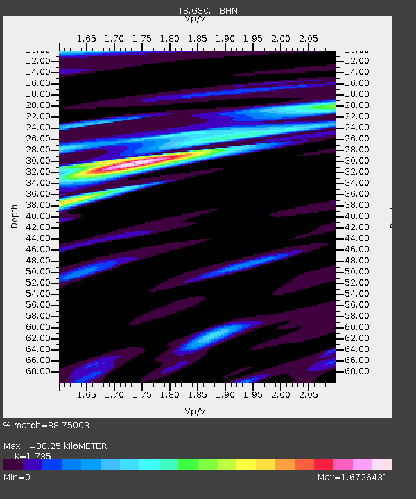
GSC Goldston, California, USA - Earthquake Result Viewer
| Earthquake location: |
Central Alaska |
| Earthquake latitude/longitude: |
62.5/-151.5 |
| Earthquake time(UTC): |
1991/05/01 (121) 07:18:42 GMT |
| Earthquake Depth: |
116 km |
| Earthquake Magnitude: |
6.1 MB, 6.4 UNKNOWN |
| Earthquake Catalog/Contributor: |
WHDF/NEIC |
|
| Network: |
TS TERRAscope (Southern California Seismic Network) |
| Station: |
GSC Goldston, California, USA |
| Lat/Lon: |
35.30 N/116.81 W |
| Elevation: |
990 m |
|
| Distance: |
34.8 deg |
| Az: |
125.24 deg |
| Baz: |
332.421 deg |
| Ray Param: |
0.07719797 |
| Estimated Moho Depth: |
30.25 km |
| Estimated Crust Vp/Vs: |
1.74 |
| Assumed Crust Vp: |
6.276 km/s |
| Estimated Crust Vs: |
3.617 km/s |
| Estimated Crust Poisson's Ratio: |
0.25 |
|
| Radial Match: |
88.75003 % |
| Radial Bump: |
400 |
| Transverse Match: |
85.82672 % |
| Transverse Bump: |
400 |
| SOD ConfigId: |
16938 |
| Insert Time: |
2010-02-26 14:15:08.882 +0000 |
| GWidth: |
2.5 |
| Max Bumps: |
400 |
| Tol: |
0.001 |
|

Signal To Noise
| Channel | StoN | STA | LTA |
| TS:GSC: :BHN:19910501T07:24:51.471008Z | 2.085922 | 4.941482E-7 | 2.3689677E-7 |
| TS:GSC: :BHE:19910501T07:24:51.471008Z | 0.7383406 | 2.8581937E-7 | 3.8711048E-7 |
| TS:GSC: :BHZ:19910501T07:24:51.471008Z | 2.7013302 | 1.0386492E-6 | 3.8449548E-7 |
| Arrivals |
| Ps | 3.8 SECOND |
| PpPs | 12 SECOND |
| PsPs/PpSs | 16 SECOND |


