You are here: Home > Network List > TA - USArray Transportable Network (new EarthScope stations) Stations List
> Station 527A Woodward Ranch, Alpine, TX, USA > Earthquake Result Viewer
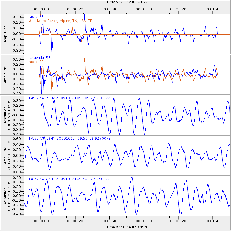
527A Woodward Ranch, Alpine, TX, USA - Earthquake Result Viewer
*The percent match for this event was below the threshold and hence no stack was calculated.
| Earthquake location: |
Santa Cruz Islands |
| Earthquake latitude/longitude: |
-12.4/166.5 |
| Earthquake time(UTC): |
2009/10/12 (285) 09:37:21 GMT |
| Earthquake Depth: |
42 km |
| Earthquake Magnitude: |
5.9 MB, 5.9 MS, 6.2 MW, 6.2 MW |
| Earthquake Catalog/Contributor: |
WHDF/NEIC |
|
| Network: |
TA USArray Transportable Network (new EarthScope stations) |
| Station: |
527A Woodward Ranch, Alpine, TX, USA |
| Lat/Lon: |
30.15 N/103.61 W |
| Elevation: |
1419 m |
|
| Distance: |
96.0 deg |
| Az: |
60.579 deg |
| Baz: |
259.223 deg |
| Ray Param: |
$rayparam |
*The percent match for this event was below the threshold and hence was not used in the summary stack. |
|
| Radial Match: |
45.809666 % |
| Radial Bump: |
367 |
| Transverse Match: |
64.06802 % |
| Transverse Bump: |
400 |
| SOD ConfigId: |
2622 |
| Insert Time: |
2010-03-06 23:26:53.332 +0000 |
| GWidth: |
2.5 |
| Max Bumps: |
400 |
| Tol: |
0.001 |
|
Signal To Noise
| Channel | StoN | STA | LTA |
| TA:527A: :BHN:20091012T09:50:12.925007Z | 2.2231634 | 3.908905E-7 | 1.7582626E-7 |
| TA:527A: :BHE:20091012T09:50:12.925007Z | 2.0635383 | 2.5623262E-7 | 1.2417149E-7 |
| TA:527A: :BHZ:20091012T09:50:12.925007Z | 1.188556 | 1.9248765E-7 | 1.6195085E-7 |
| Arrivals |
| Ps | |
| PpPs | |
| PsPs/PpSs | |


