You are here: Home > Network List > US - United States National Seismic Network Stations List
> Station BOZ Bozeman, Montana, USA > Earthquake Result Viewer
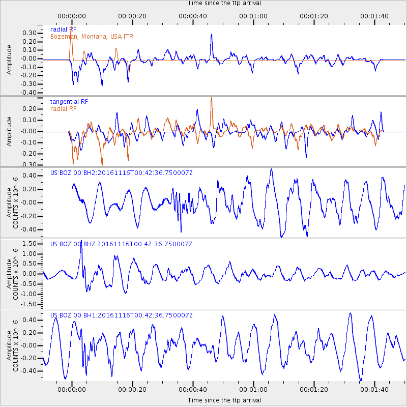
BOZ Bozeman, Montana, USA - Earthquake Result Viewer
*The percent match for this event was below the threshold and hence no stack was calculated.
| Earthquake location: |
Tonga Islands Region |
| Earthquake latitude/longitude: |
-20.2/-173.0 |
| Earthquake time(UTC): |
2016/11/16 (321) 00:30:28 GMT |
| Earthquake Depth: |
10 km |
| Earthquake Magnitude: |
5.9 MB, 5.6 MWB |
| Earthquake Catalog/Contributor: |
NEIC PDE/NEIC COMCAT |
|
| Network: |
US United States National Seismic Network |
| Station: |
BOZ Bozeman, Montana, USA |
| Lat/Lon: |
45.65 N/111.63 W |
| Elevation: |
1589 m |
|
| Distance: |
85.9 deg |
| Az: |
38.102 deg |
| Baz: |
235.715 deg |
| Ray Param: |
$rayparam |
*The percent match for this event was below the threshold and hence was not used in the summary stack. |
|
| Radial Match: |
78.90195 % |
| Radial Bump: |
400 |
| Transverse Match: |
62.22009 % |
| Transverse Bump: |
400 |
| SOD ConfigId: |
1858631 |
| Insert Time: |
2016-11-30 00:34:13.497 +0000 |
| GWidth: |
2.5 |
| Max Bumps: |
400 |
| Tol: |
0.001 |
|
Signal To Noise
| Channel | StoN | STA | LTA |
| US:BOZ:00:BHZ:20161116T00:42:36.750007Z | 3.1056325 | 5.707173E-7 | 1.8376845E-7 |
| US:BOZ:00:BH1:20161116T00:42:36.750007Z | 1.4760396 | 2.4970055E-7 | 1.6916928E-7 |
| US:BOZ:00:BH2:20161116T00:42:36.750007Z | 0.496698 | 8.447128E-8 | 1.7006568E-7 |
| Arrivals |
| Ps | |
| PpPs | |
| PsPs/PpSs | |


