You are here: Home > Network List > US - United States National Seismic Network Stations List
> Station DGMT Dagmar, Montana, USA > Earthquake Result Viewer
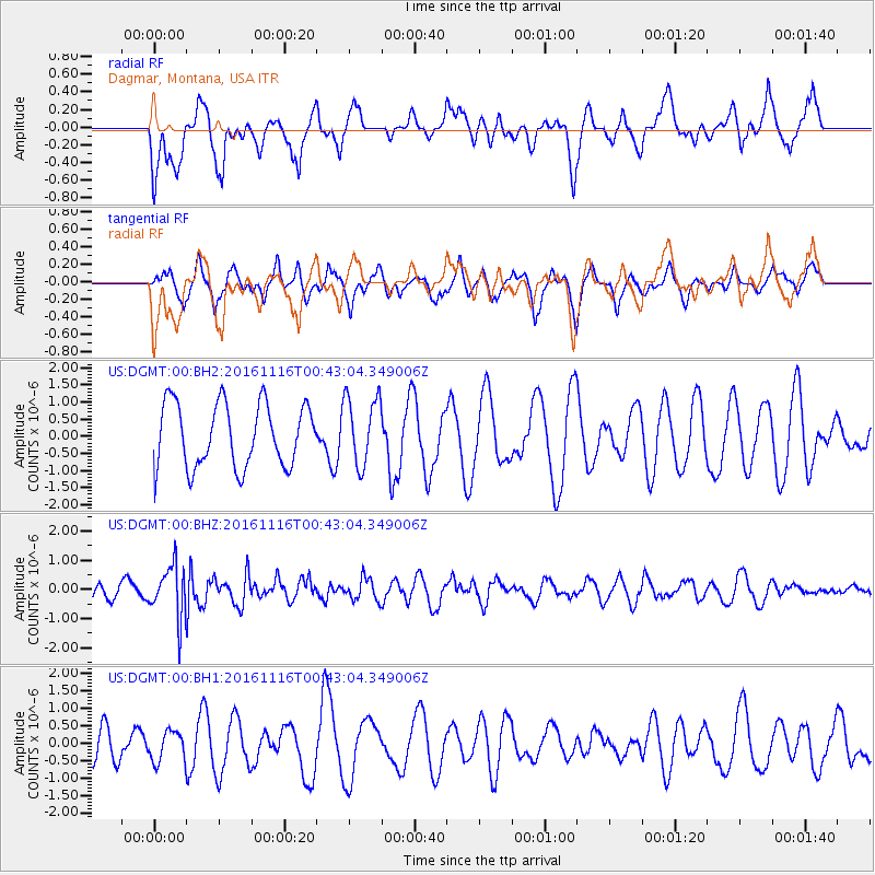
DGMT Dagmar, Montana, USA - Earthquake Result Viewer
*The percent match for this event was below the threshold and hence no stack was calculated.
| Earthquake location: |
Tonga Islands Region |
| Earthquake latitude/longitude: |
-20.2/-173.0 |
| Earthquake time(UTC): |
2016/11/16 (321) 00:30:28 GMT |
| Earthquake Depth: |
10 km |
| Earthquake Magnitude: |
5.9 MB, 5.6 MWB |
| Earthquake Catalog/Contributor: |
NEIC PDE/NEIC COMCAT |
|
| Network: |
US United States National Seismic Network |
| Station: |
DGMT Dagmar, Montana, USA |
| Lat/Lon: |
48.47 N/104.20 W |
| Elevation: |
0.0 m |
|
| Distance: |
91.7 deg |
| Az: |
38.36 deg |
| Baz: |
241.151 deg |
| Ray Param: |
$rayparam |
*The percent match for this event was below the threshold and hence was not used in the summary stack. |
|
| Radial Match: |
48.730183 % |
| Radial Bump: |
400 |
| Transverse Match: |
50.020687 % |
| Transverse Bump: |
394 |
| SOD ConfigId: |
1858631 |
| Insert Time: |
2016-11-30 00:34:20.022 +0000 |
| GWidth: |
2.5 |
| Max Bumps: |
400 |
| Tol: |
0.001 |
|
Signal To Noise
| Channel | StoN | STA | LTA |
| US:DGMT:00:BHZ:20161116T00:43:04.349006Z | 3.760292 | 8.8939123E-7 | 2.3652186E-7 |
| US:DGMT:00:BH1:20161116T00:43:04.349006Z | 1.1576446 | 4.2774192E-7 | 3.6949328E-7 |
| US:DGMT:00:BH2:20161116T00:43:04.349006Z | 1.0913517 | 1.0114212E-6 | 9.267601E-7 |
| Arrivals |
| Ps | |
| PpPs | |
| PsPs/PpSs | |


