You are here: Home > Network List > TA - USArray Transportable Network (new EarthScope stations) Stations List
> Station 126A Clayton Basin, Artesia, NM, USA > Earthquake Result Viewer
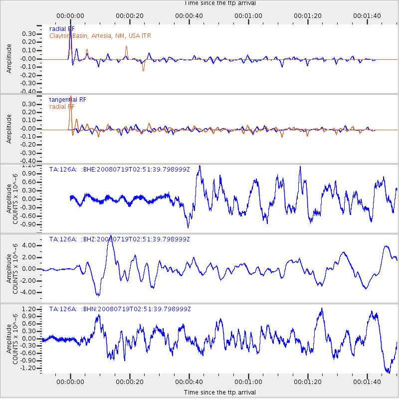
126A Clayton Basin, Artesia, NM, USA - Earthquake Result Viewer
| Earthquake location: |
Off East Coast Of Honshu, Japan |
| Earthquake latitude/longitude: |
37.6/142.2 |
| Earthquake time(UTC): |
2008/07/19 (201) 02:39:28 GMT |
| Earthquake Depth: |
22 km |
| Earthquake Magnitude: |
6.2 MB, 7.0 MS, 7.0 MW, 6.9 MW |
| Earthquake Catalog/Contributor: |
WHDF/NEIC |
|
| Network: |
TA USArray Transportable Network (new EarthScope stations) |
| Station: |
126A Clayton Basin, Artesia, NM, USA |
| Lat/Lon: |
32.65 N/104.02 W |
| Elevation: |
1032 m |
|
| Distance: |
86.8 deg |
| Az: |
50.652 deg |
| Baz: |
313.239 deg |
| Ray Param: |
0.043758187 |
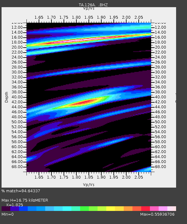
| Estimated Moho Depth: |
16.75 km |
| Estimated Crust Vp/Vs: |
1.83 |
| Assumed Crust Vp: |
6.232 km/s |
| Estimated Crust Vs: |
3.415 km/s |
| Estimated Crust Poisson's Ratio: |
0.29 |
|
| Radial Match: |
94.64337 % |
| Radial Bump: |
400 |
| Transverse Match: |
90.53649 % |
| Transverse Bump: |
400 |
| SOD ConfigId: |
2504 |
| Insert Time: |
2010-03-06 23:27:56.033 +0000 |
| GWidth: |
2.5 |
| Max Bumps: |
400 |
| Tol: |
0.001 |
|
Signal To Noise
| Channel | StoN | STA | LTA |
| TA:126A: :BHZ:20080719T02:51:39.798999Z | 3.2370043 | 4.088021E-7 | 1.2629026E-7 |
| TA:126A: :BHN:20080719T02:51:39.798999Z | 1.3461734 | 9.997787E-8 | 7.426819E-8 |
| TA:126A: :BHE:20080719T02:51:39.798999Z | 1.204405 | 1.1640104E-7 | 9.6646104E-8 |
| Arrivals |
| Ps | 2.3 SECOND |
| PpPs | 7.4 SECOND |
| PsPs/PpSs | 9.7 SECOND |


