You are here: Home > Network List > TA - USArray Transportable Network (new EarthScope stations) Stations List
> Station 126A Clayton Basin, Artesia, NM, USA > Earthquake Result Viewer
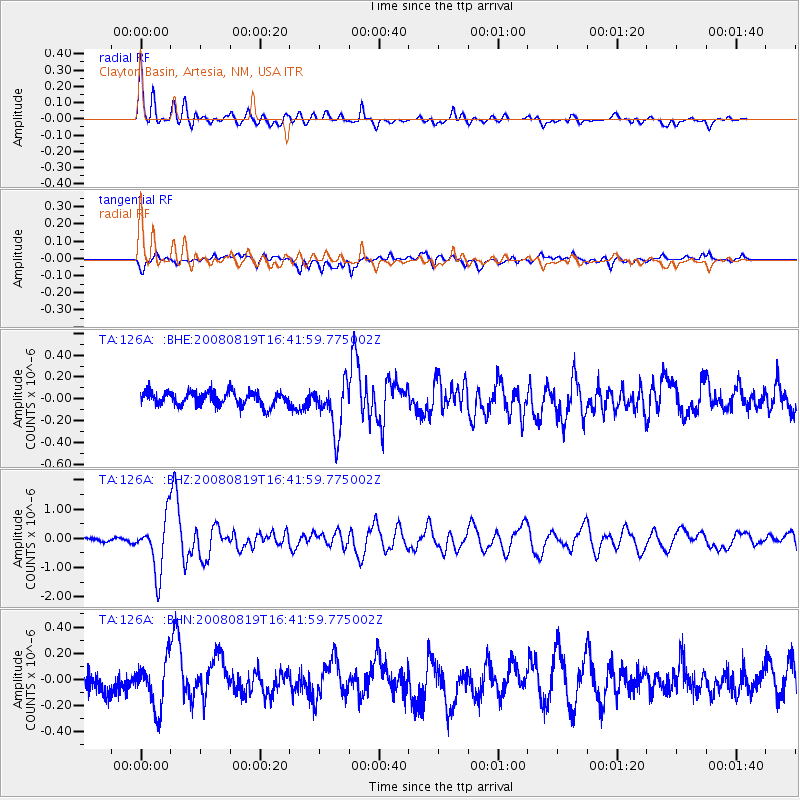
126A Clayton Basin, Artesia, NM, USA - Earthquake Result Viewer
| Earthquake location: |
Tonga Islands |
| Earthquake latitude/longitude: |
-15.1/-173.5 |
| Earthquake time(UTC): |
2008/08/19 (232) 16:30:13 GMT |
| Earthquake Depth: |
8.0 km |
| Earthquake Magnitude: |
5.6 MB, 5.9 MS, 6.1 MW, 6.0 MW |
| Earthquake Catalog/Contributor: |
WHDF/NEIC |
|
| Network: |
TA USArray Transportable Network (new EarthScope stations) |
| Station: |
126A Clayton Basin, Artesia, NM, USA |
| Lat/Lon: |
32.65 N/104.02 W |
| Elevation: |
1032 m |
|
| Distance: |
81.5 deg |
| Az: |
53.005 deg |
| Baz: |
246.133 deg |
| Ray Param: |
0.0475187 |
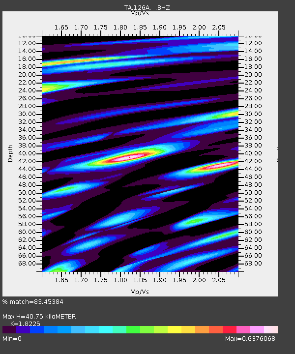
| Estimated Moho Depth: |
40.75 km |
| Estimated Crust Vp/Vs: |
1.82 |
| Assumed Crust Vp: |
6.232 km/s |
| Estimated Crust Vs: |
3.419 km/s |
| Estimated Crust Poisson's Ratio: |
0.28 |
|
| Radial Match: |
83.45384 % |
| Radial Bump: |
400 |
| Transverse Match: |
70.54849 % |
| Transverse Bump: |
400 |
| SOD ConfigId: |
2504 |
| Insert Time: |
2010-03-06 23:28:03.369 +0000 |
| GWidth: |
2.5 |
| Max Bumps: |
400 |
| Tol: |
0.001 |
|
Signal To Noise
| Channel | StoN | STA | LTA |
| TA:126A: :BHZ:20080819T16:41:59.775002Z | 9.495386 | 9.2673E-7 | 9.759793E-8 |
| TA:126A: :BHN:20080819T16:41:59.775002Z | 2.439216 | 1.7778233E-7 | 7.288503E-8 |
| TA:126A: :BHE:20080819T16:41:59.775002Z | 3.55325 | 2.236783E-7 | 6.295034E-8 |
| Arrivals |
| Ps | 5.5 SECOND |
| PpPs | 18 SECOND |
| PsPs/PpSs | 24 SECOND |


