You are here: Home > Network List > TA - USArray Transportable Network (new EarthScope stations) Stations List
> Station 126A Clayton Basin, Artesia, NM, USA > Earthquake Result Viewer
126A Clayton Basin, Artesia, NM, USA - Earthquake Result Viewer
| Earthquake location: |
Near Coast Of Peru |
| Earthquake latitude/longitude: |
-15.7/-74.8 |
| Earthquake time(UTC): |
2009/05/18 (138) 14:01:04 GMT |
| Earthquake Depth: |
23 km |
| Earthquake Magnitude: |
5.5 MS, 5.3 MB, 5.8 MW, 5.8 MW |
| Earthquake Catalog/Contributor: |
WHDF/NEIC |
|
| Network: |
TA USArray Transportable Network (new EarthScope stations) |
| Station: |
126A Clayton Basin, Artesia, NM, USA |
| Lat/Lon: |
32.65 N/104.02 W |
| Elevation: |
1032 m |
|
| Distance: |
55.6 deg |
| Az: |
330.079 deg |
| Baz: |
145.279 deg |
| Ray Param: |
0.06468434 |
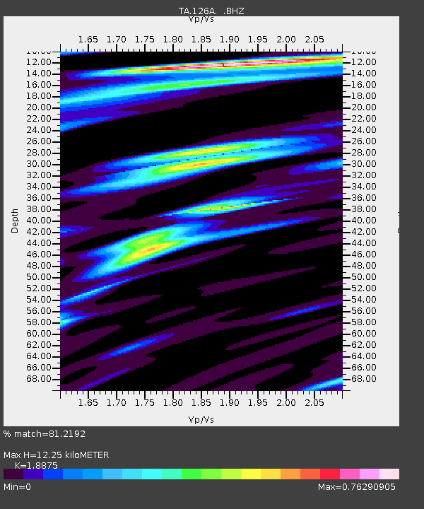
| Estimated Moho Depth: |
12.25 km |
| Estimated Crust Vp/Vs: |
1.89 |
| Assumed Crust Vp: |
6.232 km/s |
| Estimated Crust Vs: |
3.301 km/s |
| Estimated Crust Poisson's Ratio: |
0.30 |
|
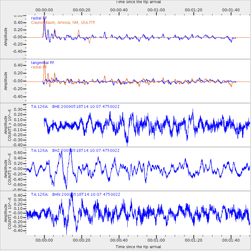
| Radial Match: |
81.2192 % |
| Radial Bump: |
400 |
| Transverse Match: |
54.35554 % |
| Transverse Bump: |
400 |
| SOD ConfigId: |
2760 |
| Insert Time: |
2010-03-06 23:28:18.748 +0000 |
| GWidth: |
2.5 |
| Max Bumps: |
400 |
| Tol: |
0.001 |
|
Signal To Noise
| Channel | StoN | STA | LTA |
| TA:126A: :BHZ:20090518T14:10:07.475002Z | 3.0021114 | 2.5450947E-7 | 8.477682E-8 |
| TA:126A: :BHN:20090518T14:10:07.475002Z | 1.2466081 | 8.052274E-8 | 6.459346E-8 |
| TA:126A: :BHE:20090518T14:10:07.475002Z | 1.0587239 | 7.8926114E-8 | 7.454834E-8 |
| Arrivals |
| Ps | 1.8 SECOND |
| PpPs | 5.4 SECOND |
| PsPs/PpSs | 7.2 SECOND |


