You are here: Home > Network List > US - United States National Seismic Network Stations List
> Station WMOK Wichita Mountains, Oklahoma, USA > Earthquake Result Viewer
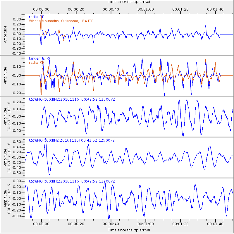
WMOK Wichita Mountains, Oklahoma, USA - Earthquake Result Viewer
*The percent match for this event was below the threshold and hence no stack was calculated.
| Earthquake location: |
Tonga Islands Region |
| Earthquake latitude/longitude: |
-20.2/-173.0 |
| Earthquake time(UTC): |
2016/11/16 (321) 00:30:28 GMT |
| Earthquake Depth: |
10 km |
| Earthquake Magnitude: |
5.9 MB, 5.6 MWB |
| Earthquake Catalog/Contributor: |
NEIC PDE/NEIC COMCAT |
|
| Network: |
US United States National Seismic Network |
| Station: |
WMOK Wichita Mountains, Oklahoma, USA |
| Lat/Lon: |
34.74 N/98.78 W |
| Elevation: |
486 m |
|
| Distance: |
89.1 deg |
| Az: |
52.417 deg |
| Baz: |
244.664 deg |
| Ray Param: |
$rayparam |
*The percent match for this event was below the threshold and hence was not used in the summary stack. |
|
| Radial Match: |
63.620865 % |
| Radial Bump: |
400 |
| Transverse Match: |
55.562218 % |
| Transverse Bump: |
312 |
| SOD ConfigId: |
1858631 |
| Insert Time: |
2016-11-30 00:34:56.272 +0000 |
| GWidth: |
2.5 |
| Max Bumps: |
400 |
| Tol: |
0.001 |
|
Signal To Noise
| Channel | StoN | STA | LTA |
| US:WMOK:00:BHZ:20161116T00:42:52.125007Z | 2.2245982 | 3.890541E-7 | 1.7488736E-7 |
| US:WMOK:00:BH1:20161116T00:42:52.125007Z | 0.8628416 | 1.3620075E-7 | 1.578514E-7 |
| US:WMOK:00:BH2:20161116T00:42:52.125007Z | 1.3910171 | 9.736984E-8 | 6.9999025E-8 |
| Arrivals |
| Ps | |
| PpPs | |
| PsPs/PpSs | |


