You are here: Home > Network List > TA - USArray Transportable Network (new EarthScope stations) Stations List
> Station 126A Clayton Basin, Artesia, NM, USA > Earthquake Result Viewer
126A Clayton Basin, Artesia, NM, USA - Earthquake Result Viewer
| Earthquake location: |
Samoa Islands Region |
| Earthquake latitude/longitude: |
-15.5/-172.1 |
| Earthquake time(UTC): |
2009/09/29 (272) 17:48:10 GMT |
| Earthquake Depth: |
18 km |
| Earthquake Magnitude: |
7.1 MB, 8.1 MS, 8.1 MW, 8.0 MW |
| Earthquake Catalog/Contributor: |
WHDF/NEIC |
|
| Network: |
TA USArray Transportable Network (new EarthScope stations) |
| Station: |
126A Clayton Basin, Artesia, NM, USA |
| Lat/Lon: |
32.65 N/104.02 W |
| Elevation: |
1032 m |
|
| Distance: |
80.7 deg |
| Az: |
52.468 deg |
| Baz: |
244.994 deg |
| Ray Param: |
0.048070222 |
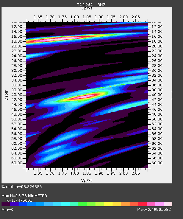
| Estimated Moho Depth: |
16.75 km |
| Estimated Crust Vp/Vs: |
1.75 |
| Assumed Crust Vp: |
6.232 km/s |
| Estimated Crust Vs: |
3.566 km/s |
| Estimated Crust Poisson's Ratio: |
0.26 |
|
| Radial Match: |
98.826385 % |
| Radial Bump: |
255 |
| Transverse Match: |
93.46193 % |
| Transverse Bump: |
400 |
| SOD ConfigId: |
2622 |
| Insert Time: |
2010-03-06 23:28:30.304 +0000 |
| GWidth: |
2.5 |
| Max Bumps: |
400 |
| Tol: |
0.001 |
|
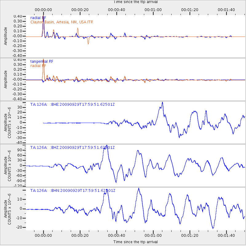
Signal To Noise
| Channel | StoN | STA | LTA |
| TA:126A: :BHZ:20090929T17:59:51.62501Z | 19.799398 | 3.2658597E-6 | 1.6494742E-7 |
| TA:126A: :BHN:20090929T17:59:51.62501Z | 5.153079 | 5.5231675E-7 | 1.0718189E-7 |
| TA:126A: :BHE:20090929T17:59:51.62501Z | 6.7497582 | 7.9815345E-7 | 1.182492E-7 |
| Arrivals |
| Ps | 2.1 SECOND |
| PpPs | 7.2 SECOND |
| PsPs/PpSs | 9.3 SECOND |


