You are here: Home > Network List > TA - USArray Transportable Network (new EarthScope stations) Stations List
> Station 126A Clayton Basin, Artesia, NM, USA > Earthquake Result Viewer
126A Clayton Basin, Artesia, NM, USA - Earthquake Result Viewer
| Earthquake location: |
Fox Islands, Aleutian Islands |
| Earthquake latitude/longitude: |
52.8/-167.0 |
| Earthquake time(UTC): |
2009/10/13 (286) 05:37:23 GMT |
| Earthquake Depth: |
24 km |
| Earthquake Magnitude: |
6.0 MB, 6.1 MS, 6.5 MW, 6.5 MW |
| Earthquake Catalog/Contributor: |
WHDF/NEIC |
|
| Network: |
TA USArray Transportable Network (new EarthScope stations) |
| Station: |
126A Clayton Basin, Artesia, NM, USA |
| Lat/Lon: |
32.65 N/104.02 W |
| Elevation: |
1032 m |
|
| Distance: |
48.8 deg |
| Az: |
88.328 deg |
| Baz: |
313.934 deg |
| Ray Param: |
0.06911332 |
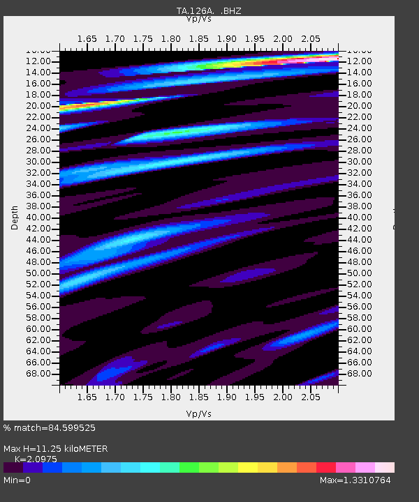
| Estimated Moho Depth: |
11.25 km |
| Estimated Crust Vp/Vs: |
2.10 |
| Assumed Crust Vp: |
6.232 km/s |
| Estimated Crust Vs: |
2.971 km/s |
| Estimated Crust Poisson's Ratio: |
0.35 |
|
| Radial Match: |
84.599525 % |
| Radial Bump: |
400 |
| Transverse Match: |
76.835205 % |
| Transverse Bump: |
400 |
| SOD ConfigId: |
2622 |
| Insert Time: |
2010-03-06 23:28:36.308 +0000 |
| GWidth: |
2.5 |
| Max Bumps: |
400 |
| Tol: |
0.001 |
|
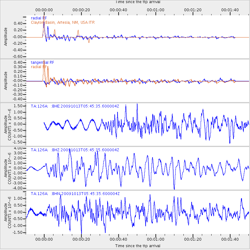
Signal To Noise
| Channel | StoN | STA | LTA |
| TA:126A: :BHZ:20091013T05:45:35.600004Z | 3.2177117 | 7.435765E-7 | 2.310886E-7 |
| TA:126A: :BHN:20091013T05:45:35.600004Z | 1.2177142 | 2.3993746E-7 | 1.9703923E-7 |
| TA:126A: :BHE:20091013T05:45:35.600004Z | 1.0649143 | 2.547828E-7 | 2.3925193E-7 |
| Arrivals |
| Ps | 2.1 SECOND |
| PpPs | 5.3 SECOND |
| PsPs/PpSs | 7.4 SECOND |


