You are here: Home > Network List > UU - University of Utah Regional Network Stations List
> Station CCUT Cedar City, UT, USA > Earthquake Result Viewer
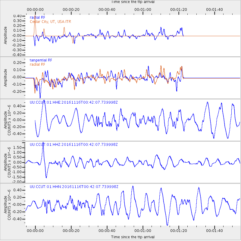
CCUT Cedar City, UT, USA - Earthquake Result Viewer
*The percent match for this event was below the threshold and hence no stack was calculated.
| Earthquake location: |
Tonga Islands Region |
| Earthquake latitude/longitude: |
-20.2/-173.0 |
| Earthquake time(UTC): |
2016/11/16 (321) 00:30:28 GMT |
| Earthquake Depth: |
10 km |
| Earthquake Magnitude: |
5.9 MB, 5.6 MWB |
| Earthquake Catalog/Contributor: |
NEIC PDE/NEIC COMCAT |
|
| Network: |
UU University of Utah Regional Network |
| Station: |
CCUT Cedar City, UT, USA |
| Lat/Lon: |
37.55 N/113.36 W |
| Elevation: |
2127 m |
|
| Distance: |
80.2 deg |
| Az: |
44.073 deg |
| Baz: |
235.288 deg |
| Ray Param: |
$rayparam |
*The percent match for this event was below the threshold and hence was not used in the summary stack. |
|
| Radial Match: |
54.95915 % |
| Radial Bump: |
400 |
| Transverse Match: |
71.332924 % |
| Transverse Bump: |
400 |
| SOD ConfigId: |
1858631 |
| Insert Time: |
2016-11-30 00:35:06.234 +0000 |
| GWidth: |
2.5 |
| Max Bumps: |
400 |
| Tol: |
0.001 |
|
Signal To Noise
| Channel | StoN | STA | LTA |
| UU:CCUT:01:HHZ:20161116T00:42:07.739998Z | 3.358959 | 6.911878E-7 | 2.0577441E-7 |
| UU:CCUT:01:HHN:20161116T00:42:07.739998Z | 0.6109823 | 8.441652E-8 | 1.3816523E-7 |
| UU:CCUT:01:HHE:20161116T00:42:07.739998Z | 0.41054773 | 9.5979075E-8 | 2.3378298E-7 |
| Arrivals |
| Ps | |
| PpPs | |
| PsPs/PpSs | |


