You are here: Home > Network List > TA - USArray Transportable Network (new EarthScope stations) Stations List
> Station 126A Clayton Basin, Artesia, NM, USA > Earthquake Result Viewer
126A Clayton Basin, Artesia, NM, USA - Earthquake Result Viewer
| Earthquake location: |
Tonga Islands Region |
| Earthquake latitude/longitude: |
-17.3/-171.9 |
| Earthquake time(UTC): |
2008/12/24 (359) 09:11:34 GMT |
| Earthquake Depth: |
9.0 km |
| Earthquake Magnitude: |
5.9 MB, 5.6 MS, 6.0 MW, 6.0 MW |
| Earthquake Catalog/Contributor: |
WHDF/NEIC |
|
| Network: |
TA USArray Transportable Network (new EarthScope stations) |
| Station: |
126A Clayton Basin, Artesia, NM, USA |
| Lat/Lon: |
32.65 N/104.02 W |
| Elevation: |
1032 m |
|
| Distance: |
81.7 deg |
| Az: |
52.179 deg |
| Baz: |
243.449 deg |
| Ray Param: |
0.0474223 |
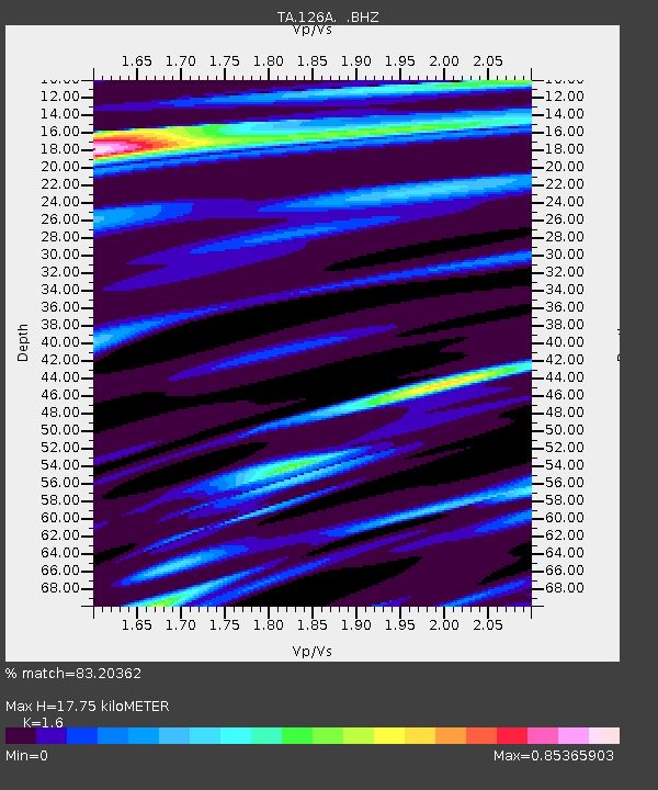
| Estimated Moho Depth: |
17.75 km |
| Estimated Crust Vp/Vs: |
1.60 |
| Assumed Crust Vp: |
6.232 km/s |
| Estimated Crust Vs: |
3.895 km/s |
| Estimated Crust Poisson's Ratio: |
0.18 |
|
| Radial Match: |
83.20362 % |
| Radial Bump: |
400 |
| Transverse Match: |
54.137955 % |
| Transverse Bump: |
386 |
| SOD ConfigId: |
2658 |
| Insert Time: |
2010-03-06 23:28:51.868 +0000 |
| GWidth: |
2.5 |
| Max Bumps: |
400 |
| Tol: |
0.001 |
|

Signal To Noise
| Channel | StoN | STA | LTA |
| TA:126A: :BHZ:20081224T09:23:21.399009Z | 1.862297 | 1.5565746E-6 | 8.358358E-7 |
| TA:126A: :BHN:20081224T09:23:21.399009Z | 0.6355405 | 3.0227386E-7 | 4.7561704E-7 |
| TA:126A: :BHE:20081224T09:23:21.399009Z | 1.0940044 | 5.229918E-7 | 4.7805275E-7 |
| Arrivals |
| Ps | 1.8 SECOND |
| PpPs | 7.2 SECOND |
| PsPs/PpSs | 9.0 SECOND |


